Earthquake-resistant Building Designs: U.S. Geological Survey to the Rescue
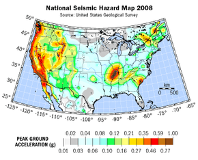
Before a major construction project begins, engineers must first evaluate the seismic activity of the building site. In the U.S., they have access to a resource to aid in this process -- National Seismic Hazard Maps prepared by the U.S. Geological Survey (USGS). These maps show the probability that ground motions will exceed a certain value in the next 50 years. To calculate the value at a specific location, geologists take historical earthquake data and then make an educated guess about ground motions from all future possible earthquake magnitudes at all possible distances from that location. The result is a colored contour map that shows which areas of the country have the highest earthquake hazard. As you might expect, the entire coast of California is an area of high hazard. Other earthquake hot spots in the U.S. include Alaska, Hawaii, South Carolina and a region encompassing southeast Missouri, southern Illinois, western Kentucky and Tennessee, and northeast Arkansas.
Building codes, such as the International Building Code used throughout most of the U.S., establish seismic design provisions based on the USGS Seismic Hazard Maps. In high-hazard areas, engineers and architects must adhere to more rigorous standards when designing buildings, bridges and highways to make sure these structures withstand earthquake shaking. At the same time, in low-hazard areas, engineers are spared from overdesigning buildings that have a low probability of experiencing severe ground motion as the result of an earthquake.
Advertisement
Once engineers determine the seismic risks of a site, they must propose an appropriate building design. In general, they avoid irregular or asymmetrical designs at all costs. These include L- or T-shaped buildings or split-level structures. Although such designs increase visual interest, they're also more susceptible to torsion, or twisting about their longitudinal axes. Instead, seismic engineers prefer to keep buildings symmetrical so that forces are distributed equally throughout the structure. They also limit ornamentation, such as cornices, vertical or horizontal cantilever projections or fascia stones because earthquakes can easily dislodge these architectural elements and send them crashing to the ground.
Symmetry alone won't save a building. We'll talk more about what can -- next.