A World of Wind
The cycle of rising and falling air demonstrated in last section's city example illustrates a basic convection cell. Convection occurs when mass movement or circulation transfers heat through a substance. A product of changing temperature and pressure, this process is one of the central components of global weather.
Imagine an Earth that doesn't rotate and doesn't experience night. In this example, let's also pretend the sun still heats the areas around the equator the most and the poles the least. This is a lot like our city example, except the entire equatorial belt would be the "city" in this scenario, and the land and sea cooling toward the poles would be the "countryside." This would result in two massive, bowl-shaped convection cells, one for each hemisphere. Surface flows of cool air would sweep toward the equator heating up along the way. Upon arrival, this air would ascend in an updraft. Then it would sweep back toward the poles in a cooling upper air wind.
Advertisement
But of course, our planet does rotate, and when we apply rotation to the hypothetical two-cell model of the world, things get complicated quickly. Besides altering periods of night and day heating and cooling the Earth, you also have three other key factors at work in global atmospheric circulation:
- Pressure-gradient force: While the equator and the poles represent major areas of air pressure differences, the planet is covered with areas of high and low pressure. These natural gradients generate additional wind, as high-pressure air flows into low-pressure areas. Meteorologists log these differences by drawing lines called isobars on charts to connect areas of equal air pressure. These typically appear as swirling layers and concentric circles around key high- and low-pressure areas. Again, this is the same principle we explored in the city example -- only imagine low- and high-pressure systems dotted throughout any given hemisphere. We call these low-pressure centers cyclones (not to be confused with hurricanes). These rotate in the familiar vortex pattern seen in hurricanes, where high-pressure winds spiral into the low-pressure center and then ascend in an updraft. We call the high-pressure centers anticyclones and, as the name implies, they're the opposite of a cyclone. High-pressure air descends in a downdraft and then spirals out along the surface into lower-pressure areas.
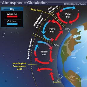
- The Coriolis force: All free-moving objects and fluids on Earth are subject to this force. In the Northern Hemisphere, winds are deflected to the right. In the Southern Hemisphere, they're deflected to the left. This force is weakest at the poles and strongest near the equator. How does this affect our model of a nonrotating Earth? It means the wind doesn't merely blow north and south from high to low pressure. Instead, the Coriolis effect forces these airflows to take an easterly or westerly direction. This breaks the hemispheric convection cells into three distinct types of cells: two Hadley cells, two Ferrel cells and two Polar cells. Hadley and Ferrel cells are named for the meteorologists who discovered them.
- Friction with Earth's surface: Wherever surface winds meet the Earth, there's the potential for friction, which slows and redirects the flow of air. Upper air winds, however, don't encounter this resistance and travel at much higher speeds as a result. This is especially evident in the jet streams, great snaking rivers of fast-moving air that exist at between 20,000 and 45,000 feet (6 and 14 km) and travel at speeds as fast as 200 miles per hour (322 kph).
These three forces dictate the power and direction of Earth's winds. But there are still localized conditions to consider wherever high- and low-pressure areas meet. These can include coastlines, mountains, valleys and areas near volcanic activity.