When Air Masses Collide
Colin Montheath/Hedgehog House/Minden Pictures/Getty Images
Cloud formation occurs when humid or water vapor-filled air rises to the point where cooler temperatures force condensation. This often involves the movement of air masses, which are large bodies of air with similar temperatures and moisture content. Air masses are typically at least 1,000 miles (1,600 km) wide and several miles thick.
Four naturally occurring mechanisms on Earth cause air to rise:
Advertisement
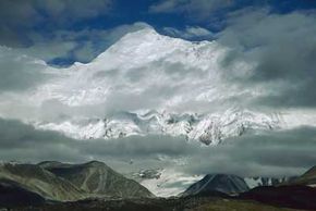
- Orographic lifting: This phenomenon occurs when an airflow encounters elevated terrains, such as mountain ranges. Like a speeding car heading toward a hill, the wind simply powers up the slope. As it rises with the topography, water vapor in the airflow condenses and forms clouds. This side of the mountain is called the windward side and typically hosts a great deal of cloud cover and precipitation. The other side of the mountain, the leeward side, is generally less lucky. The airflow loses much of its moisture in climbing the windward side. Many mountain ranges virtually squeeze incoming winds like a sponge and, as a result, their leeward sides are home to dry wastes and deserts.
- Frontal wedging: When a warm air mass and a cold air mass collide, you get a front. Remember how low-pressure warm air rises and cold high-pressure air moves into its place? The same reaction happens here, except the two forces slam into each other. The cold air forms a wedge underneath the warm air, allowing it to basically ride up into the troposphere on its back and generate rain clouds. There are four main kinds of fronts, classified by airflow momentum. In a warm front, a warm air mass moves into a cold air mass. In a cold front, the opposite occurs. In a stationary front, neither air mass advances. Think of it as two fronts bumping into each other by accident. In an occluded front, a cold front overtakes a moving warm front, like an army swarming over a fleeing enemy.
- Convergence: When two air masses of the same temperature collide and neither is willing to go back down, the only way to go is up. As the name implies, the two winds converge and rise together in an updraft that often leads to cloud formation.
- Localized convective lifting: Remember the city example? This phenomenon employs the exact same principle, except on a smaller scale. Unequal heating on the Earth's surface can cause a pocket of air to heat faster than the surrounding air. The pocket ascends, taking water vapor with it, which can form clouds. An example of this might be a rocky clearing in a field or an airport runway, as both absorb more heat than the surrounding area.
And now the stage is set for the part you've all been waiting for: storms.