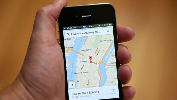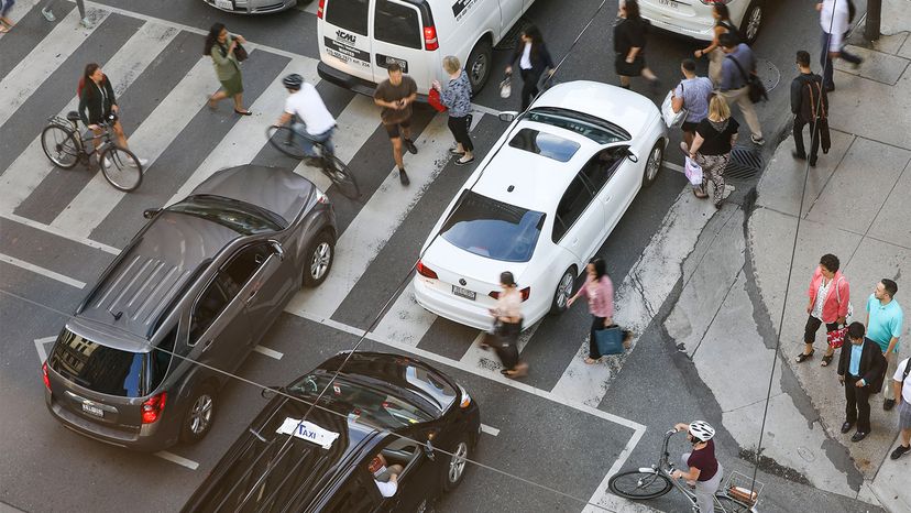
If you're a driver in a city or suburban area, it's likely that you've experienced the frustrating experience of being stuck in a long line of vehicles at a traffic light. You wait for what seems like forever until the red turns to green and the cars and trucks slowly start to move through the intersection, and then you grind to a halt again when the light turns yellow and then red. Once it's finally your turn to get across the intersection, you may only get to roll a few hundred yards before you're confronted by another light about to turn red. Yep, road rage is real and the frustration seems to be mounting every day.
Even in 2020, a year in which the pandemic shutdowns reduced traffic, drivers experienced slowdowns that added 27 hours to their commuting time (down considerably from non-pandemic years — 38 hours in 2000 and 54 in 2019) and increased their fuel costs by $605 apiece, according to a study released by the Texas A&M Transportation Institute. With streets and highways returning to normal traffic density and gasoline costs soaring, this year's numbers are likely to be much higher.
Advertisement
There's got to be a better way, right? Fortunately, engineering visionaries have been thinking the same thing for years and have developed an answer: "smart" traffic lights. They monitor incoming traffic and continuously adjust their timing to keep vehicles flowing as smoothly as possible, communicating with other lights along routes and working together to keep logjams from developing.
Numerous companies large and small are pushing smart traffic light technology ahead. In Pittsburgh, Carnegie Mellon University (CMU) research professor Stephen Smith began working on the problem back in 2009, when a local business leader approached him with concerns that worsening gridlock might interfere with Pittsburgh's efforts to transform itself from a smokestack city into a technology and health care hub.
Smith, a faculty member at CMU's Robotics Institute who studies the use of artificial intelligence to coordinate large systems in transportation, manufacturing and other fields, developed traffic signals equipped with individual computers and software with AI capabilities, which can use cameras, radar or inductive loop detectors in the pavement to spot approaching vehicles and adjust their timing.
When Smith installed a few experimental prototypes at intersections in East Liberty, a heavily congested area on the Pittsburgh's East End, he immediately got results. Drivers' average travel time to get to their destinations decreased by 25 percent, and they spent 40 percent less time idling in traffic jams, as detailed in this 2017 article.
Since then, Smith's company, Rapid Flow Technologies, has installed its Surtrac smart traffic management technology in 22 North American cities.
Unlike some other smart traffic systems, which update the timing of lights every few minutes based on recent traffic, "We generate the timing plans in real time," Smith explains. "So, we watch the traffic that's approaching the intersection. And then in real time, we generate a signal timing plan for moving that traffic through the intersection. So, we're actually scheduling the actual traffic on the road."
Smart traffic signals also can share their traffic plans with other signals along the route. "Once an intersection builds up a timing plan, and starts to execute it, it will send to its downstream neighbors, for example, what traffic it expects to be sending their way according to its schedule," Smith says.
Such smart traffic lights will become even more powerful as increasing numbers of cars and trucks employ connected vehicle technology, which enables them to communicate both with one another and with infrastructure such as traffic signals.
"If you imagine a future where all vehicles are connected, or all travelers are connected, then that's going to be transformational for traffic signal control," Smith says. Instead of relying upon spotting vehicles as they come in range of cameras, for example, smart traffic lights will be able to make decisions based on messages that they're receiving from the cars about their location and direction, or even their entire planned route in advance. But Smith thinks it will take a couple of decades for that to become the norm.
Smart traffic signals may even make it safer to have complete streets, in which cars and truck share streets with cyclists, pedestrians and people using mobility devices such as scooters. A smart traffic light can have the ability to detect pedestrians at street corners and calculate how much time they need to get across an intersection safely. Smith says his company is working on a smartphone app for pedestrians with disabilities, which would communicate with smart signals.
"If you're moving with a walker, or something like that, it knows how long you need to take get across the street," Smith explains. "So, it communicates that to the signal in advance, so that, when you do get the green light, you will be assured to get enough time to cross."
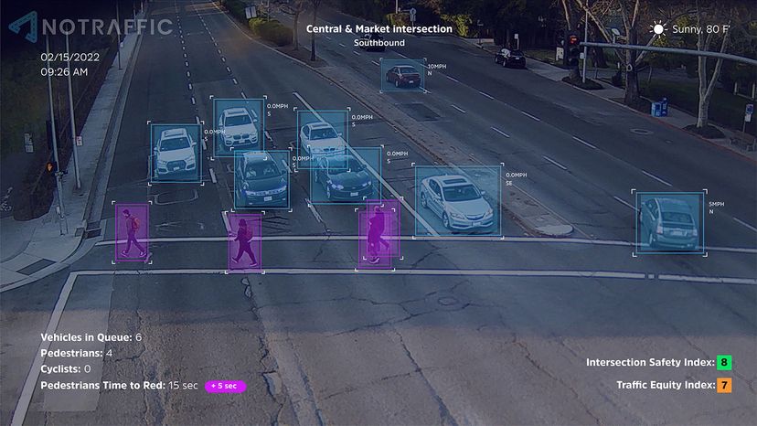
An Israeli company, NoTraffic, which Time magazine placed on its list of the 100 most influential companies of 2022, takes a somewhat different approach. Instead of decentralized smart traffic signals, it provides cities with "plug and play" Internet of Things sensors for intersections, which include cameras and radar, and combines them with a cloud-based Traffic Virtual Management Center.
"We're used to being connected at all times through our smartphones or watches, getting real-time push notifications about an approaching snowstorm or our Amazon delivery," Dvir Reznik, the company's vice president of marketing, explains via email. "But the majority of traffic lights in the U.S. aren't connected to any network — so if a traffic light isn't working, knocked-out in harsh weather or hit during an accident, the city wouldn't know about it. In addition, traffic lights are 'geared' toward vehicles, while our cities have adopted multimodal forms of transport — walking, cycling, public transport, trains and more. Our platform can detect all road users, improving traffic equity and safety, while reducing emissions."
"Improving traffic equity and safety are the key advantages of deploying the NoTraffic Platform, but the side benefits can have bigger impact moving forward," Reznik says. "We talk a lot about the potential mobility is unlocking in our communities, but the infrastructure that's required to meet the demand just isn't connected to the network. And that's where NoTraffic comes in. The first benefit is visibility and connectivity, in real time. The ability to know how many vehicles, delivery trucks, cyclists, pedestrians, buses, passed through the intersection, and optimize traffic flow autonomously, in real time."
In addition to cutting travel time and wait times at traffic signals, Reznik says that the NoTraffic system also helps to make streets safer.
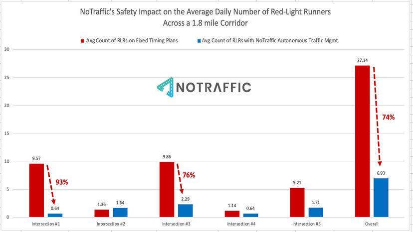
"We also demonstrated how our platform can potentially reduce the number of drivers driving through a red-light by an average of almost 80 percent, simply by optimizing the flow of traffic, in real time," he says.
While the use of adaptive signal control systems is gaining traction in the United States, it is still far from being universally accepted and implemented. Part of the reason may be cost. According to the Intelligent Transportation Systems (ITS) website of the U.S. Department of Transportation, the cost of deploying certain ITS technologies is upward of $20,000 per intersection, but the numbers for these systems vary widely depending on location and intersection upgrades that might be necessary.
Nonetheless, Reznik says smart traffic signals will become even more important once driverless autonomous vehicles come into wide use, which transportation experts predict will occur over the next several decades.
"We're headed down a path of greater connectivity in all areas, including our vehicles," Reznik says. "In order to eventually adopt autonomous vehicles on a larger scale, we need to develop infrastructure that's able to connect to individual vehicles for greater visibility and safety."
Advertisement