A subduction zone can shake things up — literally. These geological features are responsible for some of the most intense earthquakes, volcanic eruptions and tsunamis.
Advertisement

A subduction zone can shake things up — literally. These geological features are responsible for some of the most intense earthquakes, volcanic eruptions and tsunamis.
Advertisement
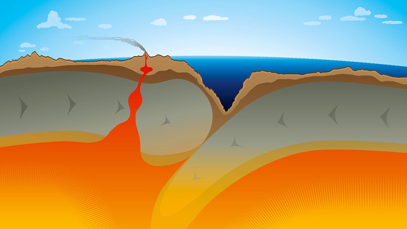
Subduction zones occur at convergent plate boundaries where two tectonic plates meet and one dives beneath the other.

A dense oceanic plate will be forced under a more buoyant plate (often a continental plate) and sinks into the mantle. Oceanic plates are typically denser and thinner than continental plates, causing them to be pulled downward.
Advertisement
As the descending plate moves deeper, it encounters high temperatures and pressures, leading to melting and the formation of magma. This means the process not only recycles the oceanic crust but also causes intense geological activity, such as creating volcanoes and explosive eruptions.
Subduction zones are responsible for powerful earthquakes, tsunamis and volcanic activity, making them some of the most geologically active and hazardous areas on Earth.
For instance, as the Juan de Fuca Plate dives into the upper mantle, it heats up, melts and forms magma, which rises to the surface. This process creates the Cascade Range, a chain of volcanoes stretching from California to Canada, including famous peaks like Mount St. Helens, Mount Rainier and Mount Hood.
Advertisement
There are a few subduction zones in the United States, like the:
Advertisement

The Pacific Ocean is home to the majority of the world’s earthquake and volcanic activity, thanks to its extensive subduction zones. The Ring of Fire, a nearly continuous belt of subduction zones encircling the Pacific, is responsible for about 90 percent of the world's earthquakes and 75 percent of its active volcanoes.
The Cascadia subduction zone is a massive fault running about 700 miles (1,126.5 kilometers) from northern California to British Columbia.
Advertisement
In the year 1700, this fault ruptured in a megathrust earthquake. Scientists know this from both geological evidence and historical records in Japan — where a massive tsunami hit without warning — and oral histories from Native Americans.
The earthquake was a massive seismic event that shook the Cascadia region of North America, affecting what is now Vancouver Island, British Columbia, Washington, Oregon and Northern California.
The Huu-ay-aht First Nation recounts that the earthquake struck at night, causing longhouses in Anacla, Pachena Bay, to sink into the sand. Similarly, the Cowichan Tribes First Nation described massive landslides and unrelenting tremors that flattened entire villages.
On the Olympic Peninsula and southern Oregon, Indigenous oral traditions recall a huge tidal wave that uprooted trees, destroyed settlements and altered river courses. In Japan, historical records detail destructive waves striking coastal towns on Jan. 27 to 28, without a preceding earthquake, confirming that a Cascadia tsunami had traveled across the Pacific.
Because the oceanic lithosphere of the Juan de Fuca Plate is being pushed down into the mantle, tremendous amounts of energy build up over centuries. When this energy is released, earthquakes occur with enough force to shake entire cities, displace land, and generate tsunamis.
The problem? Signs point to another big one on the way.
Advertisement
If you live in the Pacific Northwest, you're essentially sitting on top of a geological time bomb. The Cascadia Subduction Zone has the potential to generate large earthquakes with a magnitude of 9.0 or higher, along with tsunamis that could devastate coastal communities.
Scientists estimate that these massive quakes happen roughly every 200 to 500 years, and since the last one was over 300 years ago... well, you do the math.
Advertisement
A major earthquake in the present day would affect cities like Seattle, Portland and Vancouver.
Scientists are working hard to monitor the movements of the subducting slab, study earthquake patterns and improve early warning systems.
Residents of the Pacific Northwest can prepare by securing heavy furniture, having emergency kits ready, and knowing their tsunami evacuation routes. Awareness and preparedness could make all the difference when the next big quake strikes.
Advertisement
We created this article in conjunction with AI technology, then made sure it was fact-checked and edited by a HowStuffWorks editor.
Please copy/paste the following text to properly cite this HowStuffWorks.com article:
Advertisement