What Was the Strongest Earthquake Ever Recorded?

By: Marie Look  | 
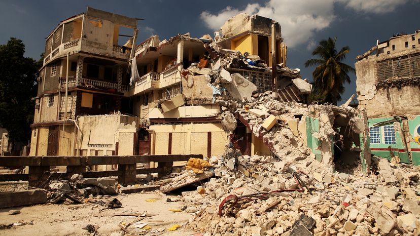
The 2010 earthquake in Haiti caused devastating damage when buildings collapsed and infrastructure failed, but the 7.1 magnitude doesn't hold a candle to the intense shaking of the five strongest ever recorded. 1001nights / Getty Images

Earthquakes are among the most powerful natural forces on Earth, often causing widespread devastation, triggering tsunamis and altering the landscape of a region. But how strong was the strongest earthquake of all time?

Let's look at the top five strongest earthquakes on record since 1900, based on data from the United States Geological Survey.

Advertisement

5 of the Strongest Earthquake Events in the World

Note that these are the earthquakes with the highest magnitudes, not the ones with the highest death tolls or most collateral damage suffered.

1. The Valdivia Earthquake: Magnitude 9.5

The Valdivia Earthquake of May 22, 1960, also known as the Great Chilean Earthquake or Gran Terremoto de Chile, remains the largest earthquake ever recorded, with a magnitude of 9.5. The quake struck the Bio-Bio region of Chile, causing intense shaking that lasted for about 10 minutes, and it triggered one tsunami wave after another across the Pacific Ocean.

Advertisement

In Chile, the death toll was estimated at around 1,600 people, with about 3,000 injured and 2 million left without homes. The tsunami waves killed more than 200 people in the coastal areas of Hawaii, Japan and the Philippines.

The earthquake also triggered the eruption of Chile's Cordón Caulle volcano, contributing further to the damage in the affected areas.

2. The 1964 Great Alaska Earthquake: Magnitude 9.2

On March 27, 1964, the southern Alaska region experienced the Good Friday Earthquake, a powerful earthquake measuring 9.2 in magnitude.

It caused severe damage in Anchorage and surrounding areas, with many buildings destroyed due to land subsidence and intense shaking. This earthquake triggered a tsunami that impacted coastal areas across the Pacific Ocean, from Alaska to California.

As a result of the low population density in some affected regions, the death toll remained at 131, though the damage caused was extensive, particularly due to the main tsunami and landslides.

3. The 2004 Sumatra-Andaman Earthquake: Magnitude 9.1

This Indian Ocean Earthquake on December 26, 2004, triggered one of the deadliest earthquakes in history. The quake struck off the west coast of northern Sumatra, generating a massive tsunami that affected more than a dozen countries, including Indonesia, Thailand, Sri Lanka and India.

The tsunami waves devastated coastal areas, killing over 230,000 people. Sumatra suffered the most widespread damage, with the tidal wave sweeping away entire communities. This event led to global efforts to improve tsunami warning systems and evacuation protocols.

4. The 2011 Tohoku Earthquake: Magnitude 9.1

On March 11, 2011, a huge earthquake occurred near the east coast of Honshu, Japan, with a magnitude of 9.1.

The intense shaking lasted for over six minutes and triggered a devastating tsunami that caused significant damage along the coast of northeastern Japan. The death toll was around 18,000, and the quake led to the meltdown of the Fukushima nuclear plant.

The tsunami waves reached as far as the Hawaiian Islands, French Polynesia, the Galapagos Islands and South America's western coast. Japan learned significant lessons from this event, particularly regarding earthquake-resistant building codes and disaster preparedness.

5. The 1952 Kamchatka Earthquake: Magnitude 9.0

A magnitude 9.0 earthquake hit the Kamchatka Peninsula in Russia on November 4, 1952. Though it was one of the largest earthquakes ever recorded, the remote location of the epicenter limited the death toll to between 10,000 and 15,000 people.

The tsunami the quake generated reached the Aleutian Islands and caused significant damage to the Hawaiian Islands, at a cost of approximately $17 million.

In Russia, the town of Severo-Kurilsk took a direct hit, with three waves between 50 feet (15.2 meters) and 60 feet (18.3 meters) high sweeping away more than a third of the 6,000 people living there at the time. The survivors rebuilt their town at a higher elevation. The event was a reminder of the destructive power of large earthquakes, even in areas with low population density.
Advertisement

The Ring of Fire: A Hotspot for Earthquakes

The Ring of Fire is a seismically active region that encircles the Pacific Ocean, stretching roughly 25,000 miles (40,250 kilometers) from South America to Japan, and from the West Coast of North America to New Zealand.

It is home to more than 450 volcanoes and the majority of the world's largest earthquakes, as it marks the boundaries of the Pacific Plate and several other major tectonic plates, such as the North American Plate and the South American Plate. The collision and subduction of these plates cause intense geological activity, including volcanic eruptions and earthquakes.

Advertisement

Many of the most powerful earthquakes in history, including the Valdivia Earthquake and the Good Friday Earthquake, occurred along the Ring of Fire. These events often trigger tsunamis, as the sudden displacement of the Earth's surface during a quake displaces water.

The region is closely monitored for seismic activity, and lessons learned from past quakes have led to improved disaster preparedness efforts in affected areas.

Advertisement

Earthquakes in California

California sits along the boundary of the Pacific Plate and the North American Plate, making it one of the most seismically active regions in the world. The state experiences frequent earthquakes, although most are minor.

Still, California is home to some of the most famous earthquakes in history, including the 1906 San Francisco earthquake (magnitude 7.9), which caused widespread devastation and was accompanied by a catastrophic fire that destroyed much of the city.

Advertisement

The damage caused by these quakes can be extensive, as seen in the 1989 Loma Prieta earthquake (magnitude 6.9) and the 1994 Northridge earthquake (magnitude 6.7), both of which caused many buildings to collapse and resulted in significant damage and loss of life.

San Andreas Fault

The San Andreas Fault runs the length of the state (and a little beyond), increasing the likelihood of large earthquakes, and experts continue to monitor for the potential of a major quake, often referred to as "The Big One."

California's rigorous building codes and emergency response systems have helped minimize the loss of life in recent events. Nevertheless, the threat of a major quake looms, particularly in densely populated urban areas like Los Angeles and San Francisco, where a large earthquake could cause widespread, catastrophic damage.

Advertisement

How Geologists Rate the Strength of Earthquakes

You may be surprised to learn that scientists have not one, not two, but three different scales to measure earthquake strength.

Richter Scale

The earthquake rating system known as the Richter scale traditionally measures the magnitude of earthquakes based on the energy released during seismic events.

Advertisement

Each whole-number increase on the magnitude scale represents a tenfold increase in measured amplitude and roughly 32 times more energy released. It classifies earthquakes as minor, moderate, strong or major, depending on their magnitude, with the largest earthquakes typically exceeding a magnitude of 8.

Moment Magnitude Scale

The Moment Magnitude Scale (Mw) is now more common because it provides a more accurate measurement, especially for larger earthquakes.

This scale measures the total energy released by an earthquake by taking into account the area of the fault that slipped, the amount of slip and the rigidity of the rocks involved.

Surface Wave Magnitude Scale

Another scale that geologists commonly use is the Surface Wave Magnitude Scale (Ms). This scale measures the size of an earthquake based on the amplitude of surface waves, which travel along the Earth's surface and cause much of the ground shaking during a quake.

This scale is particularly useful for measuring medium to large earthquakes at distances over 20 kilometers (12.4 miles) from the epicenter but is less accurate for very large or deep earthquakes, compared to the Moment Magnitude Scale.

Advertisement

Modern Recordkeeping of Earthquakes

Scientists began keeping regular records of earthquakes in the late 19th century, after the Italian physicist Filippo Cecchi produced the first seismograph in 1875. This device allowed for the systematic recording of seismic activity, marking the beginning of modern earthquake science.

By the early 20th century, scientists had established global networks of seismographs, enabling them to monitor earthquakes more consistently and develop more accurate methods of measuring their magnitude and location.

Advertisement

Prior to these technological advancements, scientists relied upon handwritten accounts of earthquakes. The first earthquake ever recorded in written history dates back to 1831 B.C.E. in ancient China. Chinese scholars noted this seismic event in historical records, though details about its magnitude or location are limited.

Ancient civilizations, including the Mesoamericans, Greeks and Romans also documented earthquakes, but these early accounts were descriptive rather than scientific.

We created this article in conjunction with AI technology, then made sure it was edited and fact-checked by a HowStuffWorks editor.

Advertisement

Advertisement

Loading...