What is a levee?

By: Marshall Brain & Robert Lamb  | 
Missouri Army National Guardsmen patrol the top of a levee next to the flooding Mississippi River.
Joe Raedle/Getty Images

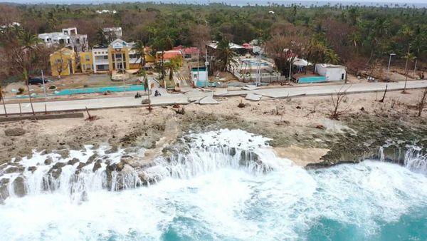
­­­In his poem "The Dry Salvages," T.S. Eliot described the river as "a strong brown god," a powerful force that, while often patient and nurturing, frequently proves itself untam­able and merciless. The greatest cities in human history have risen up on the banks of rivers and by the seaside, but in doing so, their builders chose to­ live in close confines with an unruly force. Rivers have surged to wash away whole communities or changed course to abandon prosperous kingdoms to the dust. Even today, ocean storms threaten to decimate centuries' worth of human endeavor.
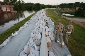
Humans have­ attempted to conquer the problems of changing water levels for thousands of years. One of the oldest weapons they've wielded against the rivers and oceans is the levee, also known as a dike. A levee is simply a man-made embankment built to keep a river from overflowing its banks or to prevent ocean waves from washing into undesired areas.

Advertisement

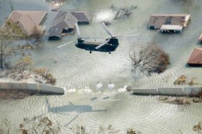
In New Orleans, the levees attempt to perform dual duties: On one side of the city, levees protect against floods from the Mississippi River, and on the other side, they help to keep Lake Pontchartrain at bay.

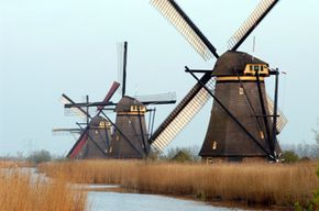
In parts of the Netherlands, dikes stop ocean waters from reclaiming thousands of miles of land, much of which is either at or below sea level. The famous windmills of Holland pump water from behind the dikes and back out to sea to keep the land dry. There are even parts of the Netherlands, called polders, where the Dutch have created new dry land along the sea by diking and draining it.

A levee is typically little more than a mound of less permeable soil, like clay, wider at the base and narrower at the top. These mounds run in a long strip, sometimes for many miles, along a river, lake or ocean. Levees along the Mississippi River may range from 10 to 20 feet (3 to 7 meters) tall. In Holland, they can top 30 feet (10 meters). But there's no set height for levees. Their measurements vary according to the storms the area receives, even if those storms occur only once every hundred or thousand years.

Living by the water provides humans with a number of advantages: fertile farm land, transportation, trade and hydroelectric power. Levees allow humans to enjoy these assets without fear of flooding. But humans have a bad habit of forgetting just how powerful their "strong brown god" really is.

Advertisement

When the Levee Breaks

A helicopter drops sand bags to plug a levee break in New Orleans following the landfall of Hurricane Katrina in 2005.
Jerry Grayson/Getty Images News/Getty Images

While strolling along the beach or enjoying a picnic by a riverbank, it's easy to forget how powerful Earth's waterways really are -- until floods and storms jar us to remember. In 1927, the Mississippi River swelled under heavy rains, charging through a line of levees and flooding an area the size of Ireland. In 1953, the North Sea broke through the Netherland's ancient system of dikes and killed thousands.

In 2005, New Orleans made international news when Hurricane Katrina breached its levees. Much of the city lies 10 feet (3 meters) below sea level. Over the course of the city's history, low-lying, boggy areas have been pumped dry to create new land. Much of this reclaimed land has sunk as it dried out. The entire city now depends on the levees, along with massive pumping stations, to keep the water out.

Advertisement

Hurricane Katrina flooded 80 percent of the city, killing approximately 1,600 people and displacing some 200,000 others [source: Dolfman et al., Gonzales]. How could this happen? An investigation by the National Science Foundation pointed to five major reasons:

  1. Insufficient planning: New Orleans' levee designs were based on an outdated 1965 study. Engineers built the levee system with the goal of creating a system that could stand up to the worst storm possible in 200 years. Unfortunately, the study greatly miscalculated how powerful potential storms could be.
  2. Riskier design: New Orleans' levees were built to sustain the city's growth, unlike the levees in neighboring areas, which were built to provide safety. As a result, New Orleans' levees were shorter and weaker.
  3. Safety compromised by bureaucracy: No central agency was in charge of maintaining the levees. This task instead fell to several different private firms and government agencies, leading to communication problems and the breakdown of various upgrade projects.
  4. Poor maintenance: Levees require constant upkeep. As the land in New Orleans sinks, so do the levees. Investigators also suspect that large trees growing nearby undermined the levees.
  5. Insufficient funds: The U.S. Army Corps of Engineers, which oversees the design and construction of levees, had been hit by budget cuts. This left the agency with fewer experienced engineers.

As New Orleans continues to rebuild from the disaster, some of these concerns are finally being addressed. The Netherlands faced a similar situation following the country's 1953 flood. How do its successes match up to New Orleans' failures?

Advertisement

Dikes of the Netherlands

The windmills of Holland pump water from behind the dikes and back out to sea to keep the land dry.
© iStockphoto.com/pidjoe

In the decades that followed the deadly flood of 1953, Dutch engineers set out to build a new kind of barrier against the sea. They steadily replaced the old dike system, which had been in place since the medieval ages, and created 3­50 miles (563 km) of what many consider the safest levee system in the world.

The Dutch set the standard for levee construction by re-evaluating their entire system in several key ways:

Advertisement

  1. Thinking long term: While the 1965 team of engineers in New Orleans tried to build levees strong enough to withstand the strongest possible storm in 200 years, Dutch engineers designed a system strong enough to match the kind of catastrophic storm that only occurs once in 10,000 years.
  2. Less reliance on solid barriers: Instead of constructing increasingly bigger barriers like levees and floodwalls, Dutch engineers have sought to create better ways of absorbing floodwaters in marsh plains and specially constructed rivers. In some cases, this even involves setting dikes farther back from the water.
  3. New textiles: The Dutch also developed tough, synthetic textiles to better anchor earthen levees. These prevent soil movement and water penetration. The New Orleans levee system began using this technology following Hurricane Katrina.
  4. Better monitoring systems: In addition to commanding more stringent, centralized control and maintenance of their dikes, the Dutch also use automated surveillance systems to keep an eye on how their levees are holding up. They installed fiber-optic and electronic sensors in dike structures to report changes back to a central monitoring station. Several other systems monitor water pressure and water level.

Much of the Dutch levee system relies on the understanding that levees require regular maintenance, constant monitoring and a long-term appreciation for how rivers, oceans and storms behave. When these are in place, communities can thrive safely alongside the beauty and convenience of coastal and riverside areas. It's when we fail to remember this that rivers and oceans become destroyers.

­Explore the links below to learn more about storms, the ocean and other feats of human and natural engineering.

Advertisement

Frequently Asked Questions

How do modern levees incorporate technology for improved safety and monitoring?
Modern levees use advanced materials like synthetic textiles to anchor the structures more securely, preventing soil movement and water penetration. Additionally, automated surveillance systems, including fiber-optic and electronic sensors, are embedded within levee structures to monitor changes in pressure and moisture levels, enabling timely maintenance and repair.
What are the challenges in maintaining and upgrading levee systems in urban areas?
One major challenge is urban sprawl, which can place increased pressure on existing levee structures. Other challenges include funding constraints, the need for continuous maintenance due to land subsidence, bureaucratic complexities involving multiple agencies, and the need to upgrade levees based on current hydrological data to withstand potential future climate change impacts and extreme weather events.

Lots More Information

Related HowStuffWorks Articles

More Great Links

Sources

  • "The App­ealing River Landscape - Green Rivers." Royal Haskoning. (Aug. 1, 2008) http://www.royalhaskoning.com/Royal_Haskoning/water_and_environment/ en-GB/Projects/Spatial/The+Appealing+River+Landscape+-+Green+Rivers.htm?ref=1
  • Dolfman, Michael L., Soldielle Fortier Wasser and Bruce Bergman. "The effects of Hurricane Katrina on the New Orleans economy." Monthly Labor Review. June 2007. (Aug. 1, 2008)http://www.bls.gov/opub/mlr/2007/06/art1full.pdf
  • Eliot, T.S. "Four Quartets." 1943.
  • Gonzales, John Moreno. "Sign of Katrina Fatigue? Storm memorial delayed." Associated Press. July 12, 2008. (Aug. 4, 2008)
  • Koenig, Robert L. "Managing our rivers: Flood control is coordinated south of Cairo." St. Louis Post-Dispatch. Aug. 29, 1993.
  • Levin, Alan and Pete Eisler. "Many decisions led to failed levees." USA Today. Nov. 3, 2005. (Aug. 1, 2008)http://www.usatoday.com/news/nation/2005-11-03-levees-failure_x.htm
  • Lougheed, Tim. "Raising the Bar for Levees." Environmental Health Perspectives. January 2006. (Aug. 1, 2007)http://www.pubmedcentral.nih.gov/articlerender.fcgi?artid=1332685

Advertisement

Loading...