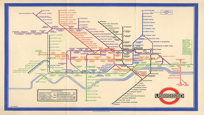
The first issue of Harry Beck's London Tube pocket map, from 1933, simplified what had been a confusing challenge for travelers trying to traverse the city. Transport for London
Unless you're a cartography buff, you probably haven't heard of Henry Charles "Harry" Beck. But you've probably seen his influence in maps of transit systems where you live.
Back in the early 1930s, Beck, a technical draftsman, came up with an ingenious way of diagramming the London Underground, aka the Tube, the British city's sprawling rail system, a way that abandoned many of the conventions of typical mapmaking.
"It looks like a cross between an electric circuit diagram and a Mondrian painting," as BBC.com culture writer Jonathan Glancey observed in 2015.
Instead of trying to squeeze in as much detail as possible, Beck actually reduced the amount of included information, stripping it down to the bare essentials that a traveler would need to know.
Advertisement
"The map simplified the layout of the lines enlarging the central area in relation to the outlying districts and using only vertical, horizontal and 45 degree diagonal lines," explains the website of the London Transport Museum. "Interchange stations were also highlighted."
When Beck submitted his design to the board of the Publicity Office of the Underground Electric Railways of London (UERL) in 1931, it initially was rejected. But after he made some minor revisions, it was accepted a year later. In 1933, 750,000 copies of Beck's map were printed and, before long, his modernistic diagram became the go-to resource for Tube travelers and is still the map used by Londoners and visitors today.
"Beck's design presented a radical step in both the history of the Underground and in the visual communication of information, because it both met the needs of travelers and revolutionized the image of traveling by Tube," Alexander J. Kent explains in an email. He's a reader in cartography and geographic information science at Canterbury Christ Church University in the U.K.
Advertisement
Stops and Connections Make London Tube Simple
While previous map designs had retained geographical fidelity, Beck understood that wasn't particularly relevant to travelers, to whom lines, stops and connections mattered most, according to Kent. Instead, "his design ruthlessly imagined traveling by Underground, and the problem of planning journeys, from a user's perspective to the extent that geography — usually crucial for a map — was discarded," says Kent.
As a result, Beck's map had a major impact. "The positive image Beck provided encouraged more people to use the Underground to get around the city because it presented the system as a rational, efficient and thoroughly modern means of transport," Kent says. "However, the effect was also to change users' mental maps of London, not just in making the city seem like a functioning metropolis, but actually affecting their geographical understanding of the city. Distance, direction and existence — i.e., whether a place is on the Tube map or not — all get distorted and continue to do so today."
Advertisement
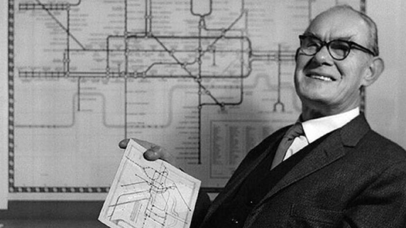
Harry Beck was an eminent 20th-century English technical draftsman who believed travelers were mainly interested in knowing how to get from one station to another and where to change trains.
London Transport Museum
While Beck's design was revolutionary, he didn't completely develop it in a vacuum.
"When appraising Beck's design, it is crucially important to look at what came before. Hence, people often overestimate the novelty of Beck's design and promulgate the myth that his map was a single stroke of innovative genius that was inherently different to anything that came before," Kent says.
The truth is more nuanced. "Looking at the evolution of the design of the map, it is possible to see that Beck built upon the advances made by his predecessors," Kent says. "For example, Max Gill removed the topographic detail from the map, freeing the depiction of the network from its geographical anchor. Fred Stingemore introduced the Johnston font and made the lines clearer to see as well as introducing more distortion. These predecessors paved the way for Beck's introduction of a geometric form to the map — limiting angles to 45 and 90 degrees — which also resonated with the Art Deco style and its penchant for movement."
Advertisement
A Map Should Be User-friendly
"Ultimately, it was Beck's user-centered approach that directed this fundamental shift in the design of the map," Kent says. "But I am not sure that he would have devised his map had the maps of Gill and Stingemore not already been there for him to improve upon."
Beck continued to refine his map design over the next several decades, before leaving government service in 1959. When he wasn't working on the map, he also designed posters for London Transport, and drew sketches and cartoons for the staff magazine as well. Starting in the late 1940s, he also tutored in typography and color design at the London School of Printing and Kindred Trades, according to the museum's article on him. He died in 1974.
Advertisement
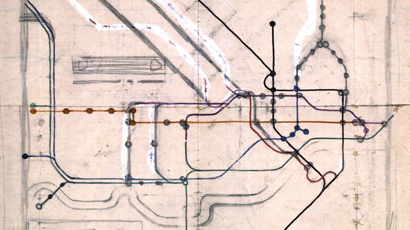
This 1931 sketch for a new map of the London Underground was drawn by Henry C. Beck in pencil and colored ink in an exercise book.
Transport for London
In 2013, Beck's birthplace in east London was commemorated with an English Heritage Blue Plaque, according to the BBC.
In his paper on Beck's map, Kent notes that there's still a lot that contemporary mapmakers can learn from Beck — not just in technique, but in his effort to understand the ordinary riders who would use his map.
"What made Beck's map so successful is that, at its core, he stripped away notions of what a map 'should' be — like retaining geographical fidelity — in favor of getting to the heart of what the users of the Underground actually needed and what the bosses of the Underground actually wanted, i.e., respectively, a clear route planner and a positive image of the system. Beck himself was a commuter, so he had some real insights into what people wanted and how to make things better for them. There are lessons here for every designer in blending form and function together to produce something that helps people do what they need to do."
Now That's Interesting
In a 2022 article for Bloomberg.com's MapLab, writer Marie Patino explored the question of whether Beck's design is due for an overhaul. Some critics say that as the system has grown, the once-minimalistic map has become too overloaded with information.
Advertisement
Frequently Answered Questions
Is there a London Underground map app?
The London Underground map is available as an app for both iOS and Android devices.
Cite This!
Please copy/paste the following text to properly cite this HowStuffWorks.com article: