Sarah Palin never said "I can see Russia from my house." Instead it was Tina Fey as Sarah Palin (above) who said the infamous line in a 2008 Saturday Night Live skit during a presser next to Amy Poehler as Hillary Clinton. NCB Universal
After a few misguided words and hyperbole from the early 21st-century American politician Sarah Palin, many U.S. citizens pondered the question: Can you see Russia from Alaska? Well, yes and no.
You can't actually see Russia from Alaska when standing on the mainland; however, there are two islands sitting in the middle of the Bering Sea that shorten the distance between the peninsulas.
Advertisement
But that begs the question: How far is Russia from Alaska? The answer varies wildly depending on whether you mean space, time or political borders.
Russia and Alaska are separated by the Bering Sea. IndianSummer/Shutterstock
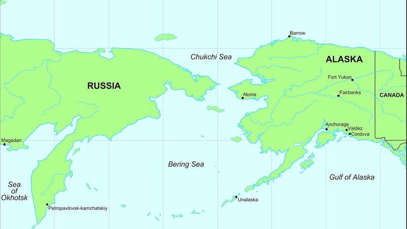
Traveling between Russia and Alaska is a monumental challenge even today. The nearest points between mainland Alaska and Russia are the western tip of Cape Prince of Wales in Alaska and the Southern point of Cape Dezhnev in Russia — with a distance of roughly 55 miles (88.5 kilometers) between the two points.
History is chock-full of heroic explorers and brave athletes who have swum, sledded and kayaked the distance, but these are exceptional outliers. There are also few major cities in this sparsely populated region of the world, so your best bet to travel between Russia and Alaska without specialized equipment is to find direct flights between international hubs like Juneau, Anchorage and Moscow.
Advertisement
Alaska
The 49th state is disconnected from the continental United States, separated by several Canadian provinces, including the Yukon Territory and British Columbia at Alaska's Southeastern border. The U.S. Government purchased the Alaska Territory from Russia in 1867, and the vast region joined the Union in 1959.
Alaska covers 663,000 square miles (1.7 million square kilometers) of land, making it the largest state by landmass. While visiting Alaska, you could see eight national parks, incredible wildlife, and cover miles and miles without seeing another person. Alaska's population has fewer than 780,000 residents, making it the third least-populated state.
Russia
Russia is the largest country in the world, spanning an incredible 57.5 million square miles (148.9 million square kilometers) from Kaliningrad on Russia's west coast, to Franz Joseph Land, the northernmost Russian territory. Mainland Russia dominates the Eastern Hemisphere, stretching west through much of Eastern Europe and east into mainland Siberia and Northeast Asia. This gargantuan country's land borders 14 countries and even extends further east than countries in the Pacific Ocean like South Korea, Fiji and New Zealand.
Advertisement
The Bering Strait and the Diomede Islands
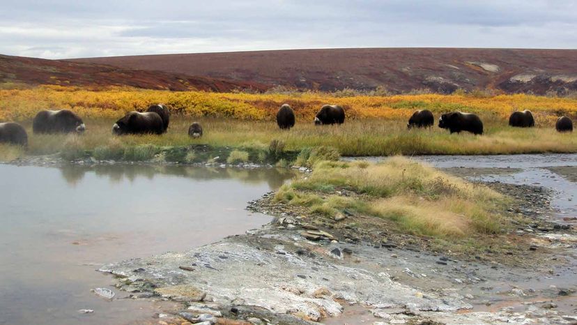
Musk ox forage on grasses in the Bering Land Bridge National Preserve before the harsh winter settles in. During the winter months, musk ox migrate vertically or to higher elevations where winds blow away snow, making it easier to find food. National Park Service
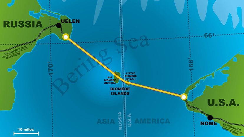
The Diomede Islands are the closest geographical connection between Alaska and Russia, with a mere 2.4 miles (3.8 kilometers) of water separating the two countries. The Chukchi Sea lies to the north, and the Bering Sea lies to the south, framing these otherwise insignificant landmasses as symbolic sentinels of either nation's farthest claims into the Pacific Ocean. However, these national declarations from both Russia and the U.S. fail to respect the Indigenous Iñupiat people's 15,000-year claim to these two islands, as well as the remaining small islands in the Arctic Sea.
The Bering Strait
This frigid waterway separates Russia and Alaska with 55 miles (88.5 kilometers) of ocean at its narrowest point between the Kamchatka Peninsula (Russia) and Seward Peninsula (U.S.). The Bering Strait is named after the Danish explorer Vitus Bering, who was the second European to discover the waterway — the first person being the Russian explorer Semyon Dezhnev, who ventured to the area 80 years earlier. Bering also mapped two islands on his travels, deciding to name them after the Greek Christian Saint Diomede, whose feast day coincided with the discovery on Aug. 16, 1728. From that day forward, the isles were known as Big Diomede Island and Little Diomede Island.
Advertisement
The Bering Strait is also one of the most important ecological zones for wildlife because it is the only marine gateway between the North Pacific and the Arctic Ocean for mass migrations of beluga, bowhead and gray whales. These whales, along with scores of various species of fish, seals and walruses, rely on the Bering Strait for access to nutrient-rich Arctic Ocean environments, such as the Beaufort Seas. Although the Bering Strait acts as a pathway, it can also become a bottleneck for increasing ship traffic that can pollute this fragile ecosystem with engine noise and oil spills.
The Big Diomede Island
This Russian island, also known as Ratmonov Island, has been the easternmost point of the country since the $7 million sale of the Alaskan Territory in 1867. Although remote, the strategic location of Russia's Big Diomede Island made it the perfect location for Soviet military outposts during World War II and the Cold War. The flat, rocky island is now home to 11 species of birds and a lone weather station that monitors storm conditions in the Chukchi Sea.
The Little Diomede Island
The smaller of the two Diomede islands is the only one with a permanent population of roughly 80 to 100 citizens. The Alaskan island's small footprint of less than 3 square miles (7.8 square kilometers) makes it accessible to the outside world only by sea or a single heliport in town. This area is the only way for residents to receive supplies from mainland Alaska, forcing locals to carve landing zones into the thick ice sheets when the islands froze during past harsh winters. Little Diomede Island is only 2.4 miles (3.9 kilometers) from its larger sister island to the west.
Advertisement
Stories From the Region's Icy Past
Here are a few interesting facts about the Bering Strait:
Bridging the Gap Between Mainland Alaska and Russia
A proposed bridge or tunnel would link Alaska and Russia, and create a route between two major continents.
Public Domain
The Bering Strait Crossing is a proposed tunnel or bridge that would connect Alaska to Russia, creating a simple transportation route between North America and Eurasia. Engineer and designer of the Golden Gate Bridge, Joseph Strauss, made the first substantial proposal for a bridge from Russia to Alaska in the 19th century, but the Russian Empire rejected the design.
Advertisement
In the 20th century, Russian Czar Nicholas approved an American proposal for a railroad connection, but these discussions abruptly ended with the Russian Revolution in 1905. Several inconclusive proposals gained little traction in the late 20th and early 21st centuries, and it seems that an "intercontinental peace bridge" joining Russia to Alaska is just a pipe dream that will never come to fruition.
There are several headwinds facing a future project proposal, including distance, cost and extreme weather conditions; however, the greatest distance separating Alaska and Russia is the deep-rooted political tensions stemming from the Cold War. So, how far is Russia from Alaska? Some feel these two nations couldn't be further apart politically.
Lynne Cox Swam Across the "Icy Curtain" in 1987
Lynne Cox became the first person ever to swim across the Bering Strait. She succeeded wearing only a bathing suit and bathing cap despite the frigid 42-degree Fahrenheit (5.5 degree Celsius) water temperature.
Bettmann Archive/Getty Images
This inspiring American swimmer has broken several long-distance swimming records in her life, but none more newsworthy than her polar plunge across the U.S./Russian maritime border known as the "Ice Curtain" Aug. 7, 1987. Cox swam across between the Diomedes Islands for two hours and six minutes in icy waters with an average temperature of 44 degrees Fahrenheit (6.6 degrees Celsius). In accomplishing this harrowing physical and political feat, Cox became the first person to cross the U.S./Soviet military boundary since its establishment following World War II. The swim also earned her much praise from both Soviet leader Mikhail Gorbachev and U.S. President Ronald Reagan at the end of the Cold War a few years later.
New Evidence Weakens the "Ice-Free Corridor" Hypothesis
Originally proposed by Louis Agassiz in 1840, the traditional "Ice-Free Corridor" theory states that early humans migrated from Europe to the Americas across a land bridge linking Europe and Asia to the Americas after the last ice age 13,000 years ago. Once crossing from modern-day Russia to Alaska in pursuit of megafauna prey, these Clovis-culture hunter-gatherers would have potentially waited for thousands of years with limited resources for the Laurentide and Cordilleran ice sheets to melt before continuing their route south along the Rockies to the continental United States and South America.
Recent discoveries of Clovis sites in Chile and Florida dating back 15,000 years have forced researchers to reevaluate the Ice-Free Corridor Hypothesis and develop new models to answer how humans first discovered the Americas.
Now That's Bizarre
Maritime borders separate countries at specific locations in oceans and seas. One of the most bizarre occurrences of this is along the international date line, which separates the Bering Strait Islands, known as Big Diomede Island and Little Diomede Island. The international date line separates these small islands by 21 hours, earning them the nicknames "Yesterday Island" and "Tomorrow Island."
Advertisement
Frequently Asked Questions
What are the geopolitical implications of the proximity between Russia and Alaska?
The implications include strategic military considerations, due to their close distance across the Bering Strait. This narrow separation has historically influenced defense policies, especially during the Cold War era, and continues to impact diplomatic relations and military readiness in both countries today.
How does the wildlife in the Bering Strait region adapt to the unique environmental conditions?
Wildlife in the Bering Strait region adapts to unique environmental conditions through various survival strategies. Many species have evolved to withstand extreme cold and scarce food resources. For example, marine mammals like seals and whales have thick blubber for insulation, while migratory birds exploit the productive summers for breeding before flying south for the winter.
Cite This!
Please copy/paste the following text to properly cite this HowStuffWorks.com article: