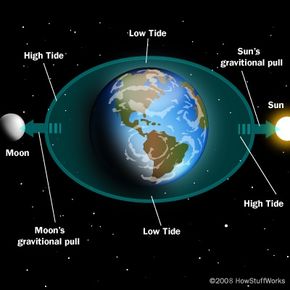
Time and tide wait for no man, not even a little boy rushing to finish his sand castle before it gets washed away. With amazing regularity, the Earth's oceans rise and fall daily, due to the gravitational attraction of the moon and sun on the Earth's surface. These changes in water level are called tides, and knowing when they will occur is essential to a variety of people, including the budding architect on the beach.
Government agencies throughout the world measure tides daily to predict when the two highest and lowest tides in an area will occur and how high they will be. This compilation of data is called a tide table. Tides have little effect in the open ocean and in lakes, so tables mainly are generated for coastal areas, inlets, bays and estuaries.
Advertisement
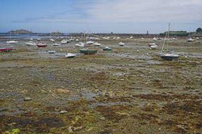
Not surprisingly, boats rely heavily on tidal information. Traveling through shallow ports and narrow intracoastal waterways or under bridges is a risky venture if you don't know what's going on with the tides. Depending on the area, the difference between high and low tides, or the tidal range, may be more than 49 feet (15 meters) [source: NOAA: Tides and Water Levels]. If you're a sea captain steering your ship under a low bridge, underestimating the range could be devastating.
Fishermen often draw on information about the tides to improve their catches since certain species of fish may congregate during periods of high or low water. In addition, strong tidal currents can corral fish into one area, and if fishermen know when that current will occur, they'll hit the jackpot.
Tide tables are also useful in planning coastal construction projects, as well as coastal rehabilitation work and disaster cleanups. Many people use the tables for recreational pursuits, too, such as surfers looking to catch the ultimate wave.
On the next page, find out how a division of NOAA prepares tide tables and why its predictions aren't always 100 percent accurate.
Advertisement