Prev NEXT

What are tide tables?

Tide Table Predictions

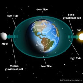
Tides depend on several factors, including where the sun and moon are relative to the Earth. When the moon and the sun line up with the Earth, as they do here, a high tide occurs.
HowStuffWorks

The height of tides is determined by a complex combination of factors relating to the positions of the Earth, sun and moon. Because the moon revolves around the Earth, the Earth revolves around the sun and the Earth also rotates on its own axis, the distances between the three bodies and their relative positions to one another constantly change. Depending on this distance and position, tides may be higher or lower, and tidal currents may be stronger or weaker.

For example, when the moon and sun align with the Earth, tides are stronger because the attraction of the moon and the sun combine. When they form a right angle with the Earth, their pulls partially cancel each other out, so the tides are weaker. The moon's gravitational attraction has more effect on tides than the sun's because it is 390 times closer to the Earth. Thus, its pull is twice as strong as the sun's [source: NOAA: Tides and Water Levels].

Advertisement

Although tidal characteristics are largely determined by these regularly occurring and predictable astronomical forces, constructing tide tables isn't an exact science. Among other things, factors such as existing ocean currents, winds, the contour of the ocean bottom and existing land masses must be accounted for. Existing ocean currents and winds, depending on their direction, can either negate or accentuate a tide's pull; while topography -- both above and below the ocean surface -- can slow tides down, speed them up and even raise or lower their height.

The most accurate tidal predictions usually exist for places located on the coast because they are less affected by winds and other meteorological events. Areas with shallow water or in a bay are more affected by alternate factors. For example, an estuary fed by a river might see tidal levels several feet higher than predicted if heavy rains flush in river water. An inland harbor that receives strong winds might have lower-than-predicted tides if the winds blow against the incoming tide.

In the United States, the Center for Operational Oceanographic Products and Services, or CO-OPS, (a branch of the National Ocean Survey), is the official source of predictions for approximately 3,000 locations around the country. CO-OPS also makes predictions for other countries and territories.

Since astronomical data are not sufficient to calculate tides, predictions also are based on actual tidal measurements in many areas over an extended period. For these observations, the National Ocean Survey maintains a network of 140 tide stations that house equipment to take the following measurements every six minutes:

  • tide levels
  • wind speed and direction
  • water current speeds and directions
  • air and water temperatures
  • barometric pressure

The collected data is relayed to the center every hour and is immediately available on the Internet from links such as the ones listed below.

Stations that provide these full daily predictions are called reference stations. The rest of the stations are subordinate stations, which obtain their predictions by applying a specific formula to the data obtained at the reference stations. That formula is derived by observing how tides at the two stations related to one another in the past.

With the vast network of tide stations and large compilation of tide tables available to anyone with an Internet connection, you shouldn't have too much trouble building that sand castle -- even if tides don't wait. For more information on tides and tide tables, look into the links below.

Related HowStuffWorks Articles

More Great Links

Sources

  • U.S. National Oceanographic and Atmospheric Administration (NOAA). "Our Restless Tides." February 1998. (April 17, 2008) http://www.co-ops.nos.noaa.gov/restles1.html
  • U.S. National Oceanographic and Atmospheric Administration (NOAA). "Tides and Currents FAQ." March 25, 2008. (April 17, 2008) http://www.co-ops.nos.noaa.gov/faq2.html
  • U.S. National Oceanographic and Atmospheric Administration (NOAA). "Tides and Water Levels." March 25, 2008. (April 17, 2008) http://oceanservice.noaa.gov/education/kits/tides/welcome.html

­