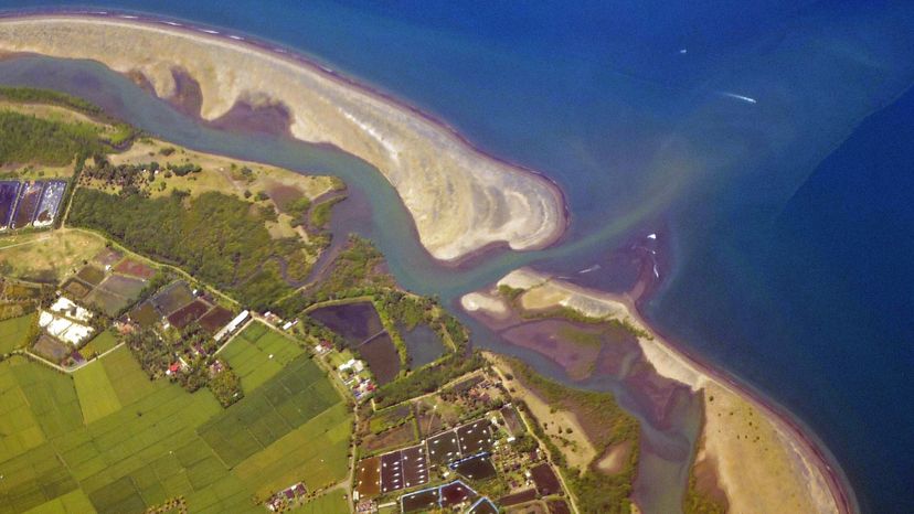
A sandbar barrier island protects the mangrove forest from ocean waves. Photography by Mangiwau / Getty Images
Barrier islands, sometimes called barrier spits, are found on coastlines all over the world. However, they are most noticeable along the east coast of North America, where they extend from New England down the Atlantic Coast, and along the gulf coast south to Mexico.
Barrier islands are popular vacation spots, including resort communities from Atlantic City, New Jersey, to Miami Beach, Florida. Many people own vacation homes or condominiums on barrier islands, and more barrier islands are being developed for tourism. However, barrier islands are fragile, constantly changing ecosystems that are important for coastal geology and ecology. Development has not only posed dangers to these ecosystems but also increased the risk of property damage every year from hurricanes and Nor'easters.
Advertisement
In this article, we will examine the fragile ecosystems of barrier islands. We'll explore how these islands are formed, plus what habitats and life are present on them. In addition, we'll find out how they change, the consequences of development, and the recreational activities that attract tourists to them every year.
Barrier islands are long, narrow, offshore deposits of sand or sediments that parallel the coast line. Some barrier islands can extend for 100 miles (160 km) or more. The islands are separated from the main land by a shallow sound, bay or lagoon. Barrier island chains are often found along the coast line and are separated from each other by narrow tidal inlets, such as the Outer Banks of North Carolina.
How barrier islands form is complex and not completely understood. The current theory is that barrier islands were formed about 18,000 years ago when the last Ice Age ended. As the glaciers melted and receded, the sea levels began to rise, and flooded areas behind the beach ridges at that time.
Advertisement
The rising waters carried sediments from those beach ridges and deposited them along shallow areas just off the new coastal ridges. Waves and currents continued to bring in sediments that built up, forming the barrier islands. In addition, rivers washed sediments from the mainland that settled behind the islands and helped build them up.
Barrier islands serve two main functions. First, they protect the coastlines from severe storm damage. Second, they harbor several habitats that are refuges for wildlife. Let's take a look at the parts of a typical barrier island.
Advertisement
Barrier-island Zones
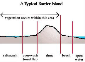
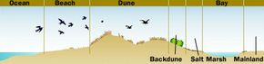
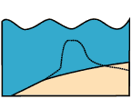
Various zones of a typical barrier island
Photo courtesy USGS
The structure of a typical barrier island consists of the following zones, from the ocean side toward the sound side:
Beach - consists of sand deposited by the actions of waves
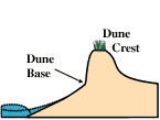
Dunes - formed from sand carried and deposited by winds. Dunes are stabilized naturally by plants (sea oats, bitter pancum) and artificially by fences. The primary dune faces the ocean and may be followed by secondary and tertiary dunes inland.
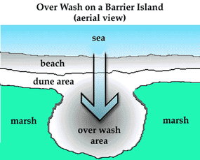
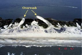
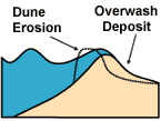
Barrier flat (also called backdune, overwash or mud flat) - formed by sediments that get pushed through the dune system by storms, such as hurricanes. Grasses grow and stabilize these areas.
Storms push sediments through to form the overwash
Photos courtesy USGS
Storms push sediments through to form the overwash
Photos courtesy USGS
Salt marsh - a low-lying area on the sound-side of a barrier island. Salt marshes are generally divided into high and low marsh areas. High marsh areas get flooded twice each month with the spring tides, while low marsh areas get flooded twice daily with the high tides. Cord grasses stabilize the salt marsh area, which are one of the most ecologically productive areas (amount of vegetation per acre) on Earth. In fact, the salt marsh ecosystems of the islands and the coast help to purify runoffs from mainland streams and rivers.
Each of these zones has distinct animal and plant life, which we will discuss in the next section.
Advertisement
Advertisement
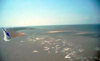
Barrier-island Habitats
Barrier-island profile showing various habitats
Photo courtesy U.S. Air Force
Even though barrier islands are narrow, they have several distinct habitats. We've already determined that these habitats are as follows: beach, dune, barrier flat, and salt marsh. Each habitat has varying conditions and wildlife, which we'll look at individually.
Beach Habitat
On the ocean side is the barrier island's beach habitat. The beach is much like a desert in that it lacks fresh water, but a large portion of the beach gets covered almost entirely with salt water twice daily (the entire beach gets covered to the dune base during storms). Animals and plants in this environment (known as the intertidal zone, between tides) must endure long periods of exposure to salt water and drying air.
Advertisement
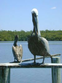
On the beach, the only plant life you'll see is some algae that get washed ashore. Bacteria live in the spaces between the sand grains where water from the surf percolates through. The animals on the beach itself include burrowing animals like mole crabs and clams that filter-feed during high tides, burrowing worms that feed on bacteria in the sand, scavenging crabs (ghost crabs) and various shorebirds (sandpipers, seagulls and pelicans) that eat the crabs, burrowing animals and offshore fish.
Brown pelicans often feed on both the ocean and sound sides of barrier islands
Photo courtesy USGS
Dune Habitat
The dunes receive moisture from rain and surf and are occasionally flooded during severe storms. The dunes are still a relatively hostile environment with high salt content, sandy soil and little fresh water.
Plants such as sea oats and bitter pancum provide stability to the dunes. Their root systems hold the sand in place and their shoots slow the winds, thereby allowing sand to be deposited. Along the dunes, you will find many crabs, particularly ghost crabs. Again, you will find birds (gulls, terns) that feed on the animals that inhabit the dunes.
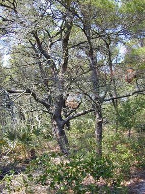
Scrub tree community of a maritime forest
Photo courtesy USGS
After the dunes, some islands may have maritime forests with shrubs and trees (Sand Live Oak, Myrtle Oak, Slash Pine, and Magnolia). Animals in these forests include various snakes, opossums, skunk, raccoon, and fox.
Barrier-flat Habitat
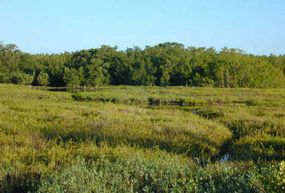
On other islands, the barrier flats come after the dunes. The primary vegetation includes cordgrass and sawgrass. These areas are often flooded daily during high tides. The muds and sediments are full of anaerobic bacteria, as there is little oxygen in the sediments. The bacteria decompose the rich organic material in the sediments and from dead plants and animals.
Animals that live in the wet muds filter-feed bacteria and plankton from the tidewaters or feed on bacteria in the muds; these animals include clams, mussels, snails and worms. Various fish come and go with the tides. Fiddler crabs feed on the bacteria in the muds. Ghost crabs and blue crabs feed on the bacteria, small invertebrates and small fish. Various birds (seagulls, egrets, pelicans) feed on the fish, crabs and invertebrates.
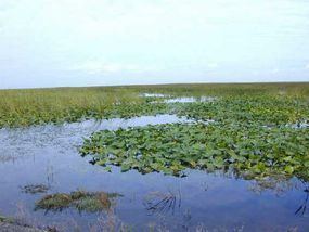
Sawgrass community on a barrier flat (top) and salt marsh community on the sound side (bottom)
Photo courtesy USGS
Sawgrass community on a barrier flat (top) and salt marsh community on the sound side (bottom)
Photo courtesy USGS
Salt-marsh Habitat
The sound-side of an island is usually dominated by the salt marsh. The salt marshes that you find on the sound sides of barrier islands are similar to those found on the coastal mainland. Like the barrier flats, salt marshes are regularly flooded with seawater during high tide and the animals and plants that you find are similar to those in the barrier flats.
Did You Know?
Because decomposition occurs in the absence of oxygen, the mud flats in the barrier-flats habitat tend to smell rotten.
Advertisement
Nature's Effects on Barrier Islands
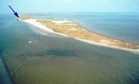
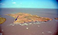
Changes in Louisiana's Isle Dernieres barrier island before (top images) and after (bottom images) Hurricane Andrew in 1992. The arrows indicate identical, corresponding points on the top and bottom images.
Photo courtesy USGS
A barrier formation is constantly changing. They are influenced by the following conditions:
Waves - Waves continually deposit and remove sediments from the ocean side of the island.
Currents - Longshore currents that are caused by waves hitting the island at an angle can move the sand from one end of the island to another. For example, the offshore currents along the east coast of the United States tend to remove sand from the northern ends of barrier islands and deposit it at the southern ends.
Tides - The tides move sediments into the salt marshes and eventually fill them in. Thus, the sound sides of barrier islands tend to build up as the ocean sides erode.
Winds - Winds blow sediments from the beaches to help form dunes and into the marshes, which contributes to their build-up.
Sea level changes - Rising sea levels tend to push barrier islands toward the mainland.
Storms - Hurricanes and other storms have the most dramatic effects on barrier islands by creating overwash areas and eroding beaches as well as other portions of barrier islands.
Changes in Louisiana's Isle Dernieres barrier island before (top images) and after (bottom images) Hurricane Andrew in 1992. The arrows indicate identical, corresponding points on the top and bottom images.
Photo courtesy USGS
Changes in Louisiana's Isle Dernieres barrier island before (top images) and after (bottom images) Hurricane Andrew in 1992. The arrows indicate identical, corresponding points on the top and bottom images.
Photo courtesy USGS
Changes in Louisiana's Isle Dernieres barrier island before (top images) and after (bottom images) Hurricane Andrew in 1992. The arrows indicate identical, corresponding points on the top and bottom images.
Photo courtesy USGS
Advertisement
How Storms Affect Barrier Island Chains
The impact of storms on barrier islands depend upon qualities of the storm (storm surge, waves) and upon the elevation of the barrier island at landfall. To quantify the impact of storm damage, the U.S. Geological Survey (USGS) has devised a "hazard scale" as follows:
Impact 1 - Wave erosion is confined to beach area. The eroded sands will be replenished in a few weeks to months and no significant change occurs in the system.
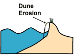
Impact 2 - Waves erode the dune and cause the dune to retreat. This is a semi-permanent or permanent change to the system.
Impact 3 - Wave action exceeds the dune's elevation, destroys the dune and pushes sediment from the dune landward (approximately 300 yards/100 m), thereby creating overwash. This change in the system pushes the barrier island landward.
Impact 4 - The storm surge completely covers the barrier island, destroys the dune system and pushes sediments landward (approximately 0.6 miles/1 km). This is a permanent change to the barrier island or portions of it.
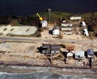
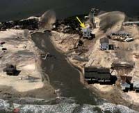
The storm impact hazard scale (top left: impact 1, top right: impact 2, bottom-left: impact 3, bottom-right: impact 4)
Photo courtesy USGS
The storm impact hazard scale (top left: impact 1, top right: impact 2, bottom-left: impact 3, bottom-right: impact 4)
Photo courtesy USGS
The storm impact hazard scale (top left: impact 1, top right: impact 2, bottom-left: impact 3, bottom-right: impact 4)
Photo courtesy USGS
The storm impact hazard scale (top left: impact 1, top right: impact 2, bottom-left: impact 3, bottom-right: impact 4)
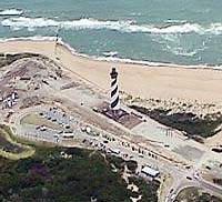
In 1999, the Cape Hatteras Lighthouse was carefully and slowly moved about one-half mile (.8 km) inland.
Photo courtesy National Park Service
Many barrier islands are being developed as popular vacation spots. Resort communities are being built, including high-rise hotels, condominiums, and golf courses. To accommodate these structures, sand dunes are destroyed and salt marshes and barrier flats are filled in. In some cases, humans have tried to fight the natural erosion processes on barrier islands, with mixed results. Let's look at two examples.
Cape Hatteras Lighthouse
Barrier islands such as Hatteras Island, NC, where the Cape Hatteras Lighthouse is located, are constantly changing. Offshore currents carry sand away from one end of the island and deposit it at the other end, thereby changing the shape of the island.
Advertisement
The Cape Hatteras Lighthouse has guided mariners since the 1800s. Because of the eroding beach around it, the lighthouse was in danger of falling into the Atlantic Ocean. In 1989, officials decided to move the lighthouse from the site where it had stood for over 100 years to a new site inland about 2900 feet (about .5 mile/.8 km). Years of reports, studies and public hearings delayed the move until 1999.
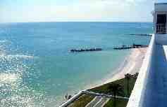
Upham Beach, Florida
Sand erosion by longshore currents and wave actions can dramatically change a beach. To preserve the beach, humans must renourish it with sand dredged from other sources, a process known as beach nourishment. Beach nourishment is an expensive undertaking, often costing millions of dollars.
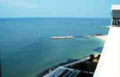
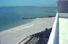
As you can see below, beach nourishment in Upham Beach -- a destination in west central Florida -- did not last. Within a year, the offshore currents eroded the replenished sand. At best, beach nourishment is an expensive, temporary effort to halt the inevitable shifting sands of barrier islands. In the next section, we'll look at some dramatic effects that development has had on barrier islands.
Beach nourishment in Upham Beach, FL (top: before; middle: soon after; bottom: one year later)
Photo courtesy USGS
Beach nourishment in Upham Beach, FL (top: before; middle: soon after; bottom: one year later)
Photo courtesy USGS
Beach nourishment in Upham Beach, FL (top: before; middle: soon after; bottom: one year later)
Photo courtesy USGS
Coastal Attractions
People vacation on barrier islands each year. Activities include swimming, sunbathing, surf fishing, snorkeling, deep-sea/sound fishing, boating, nature watching, and sea kayaking.
Advertisement
Development's Effects on Barrier Islands
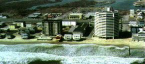
Ocean City, MD -- an urbanized barrier island
Photo courtesy USGS
Development has important effects on barrier island ecosystems, which are dynamic in nature. Several environmentalists, as well as noted geologist Orrin Pilkey of Duke University, have spoken about the dangers of building on barrier islands. Let's look at two barrier islands that have been drastically changed by development.
Ocean City, Maryland
Ocean City, which is located at the southern end of Fenwick Island along Maryland's eastern shore, has been a popular beach resort for a long time. In the 1920s, several large hotels were built there, and by the 1950s, development boomed dramatically and lasted for almost 30 years. In the 1970s, ecological concerns about the island were raised, and laws were enacted to halt dredging of channels and filling in wetlands.
Advertisement
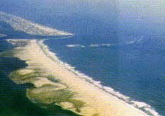
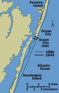
A hurricane opened the Ocean City Inlet in 1933 (the inlet separates Fenwick Island from Assateague Island to the south). To keep the channel navigable to the mainland, the U.S. Army Corps of Engineers constructed two rock jetties. Although the jetties stabilized the inlet, they altered the normal north-to-south sand transport by the longshore currents.
The result is that sand built up behind the north jetty and the sand below the south jetty was quickly eroded. The accelerated erosion has shifted Assateague Island almost one-half mile (.8 km) inland. In a very short time, human interventions have permanently altered the barrier island profile.
Changes in Assateague Island as a result of accelerated erosion from the man-made rock jetties of Ocean City Inlet (top: photo of the inlet, bottom: map of the area with outline showing the position of the island in 1849).
Photo courtesy USGS
Changes in Assateague Island as a result of accelerated erosion from the man-made rock jetties of Ocean City Inlet (top: photo of the inlet, bottom: map of the area with outline showing the position of the island in 1849).
Photo courtesy USGS
Topsail Island, North Carolina
Topsail Island is a popular beach vacation spot along the North Carolina coast. This barrier island was extensively developed for tourism with the construction of condominiums and beach houses. In September 1996, Hurricane Fran made landfall near Wilmington, NC. The counterclockwise air circulation around the hurricane's eye caused heavy wave action and storm surges over Topsail Island.
The storm eroded much of the island, causing overwashes. Several places on the island were eroded, and the island's only highway was seriously damaged. Residential homes were destroyed, and property damage was valued at several-hundred-million dollars.
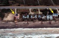
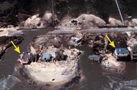
Hurricane Fran damaged Topsail Island in 1996 (top: before, bottom: after).Note how the overwash damaged the road and even broke through the island in places.
Photos courtesy USGS Photos courtesy USGS
Hurricane Fran damaged Topsail Island in 1996 (top: before, bottom: after).Note how the overwash damaged the road and even broke through the island in places.
Photos courtesy USGS Photos courtesy USGS
Hurricane Fran damaged Topsail Island in 1996 (top: before, bottom: after).Note how the overwash damaged the road and even broke through the island in places.
Photos courtesy USGS Photos courtesy USGS
Hurricane Fran damaged Topsail Island in 1996 (top: before, bottom: after).Note how the overwash damaged the road and even broke through the island in places.
Photos courtesy USGS Photos courtesy USGS
Although barrier-island development is a risky business, these islands continue to be popular vacation and recreational attractions. Because barrier islands serve important functions (protecting the coasts from storm damage, nurturing ecosystems, and protecting wildlife), a balance is needed between conservation and further development.
For more information on barrier islands, check out the links on the next page.