What Is a Glacier? Everything to Know About These Ice Masses

By: Ed Grabianowski & Desiree Bowie  | 
Here, you can see the path of the retreating Margerie Glacier in Glacier Bay, Alaska Danny Lehman / Getty Images

Glaciers have long captured both our imagination and scientific curiosity. Beyond their critical role in shaping Earth's landscapes, glaciers have also left an indelible mark on popular culture. From grand, cinematic adventures like "The Day After Tomorrow," where humanity grapples with a world gripped by ice, to the chilling spectacle of glaciers calving in documentaries like "Chasing Ice," these frozen giants have fascinated and inspired.

But what is a glacier? And how does it form? While answering these questions, let's also take a look at reports that the world's glaciers are shrinking to find out what that means for our future.

Advertisement

­What Is a Glacier?

Glaciers are the largest ­moving objects on Earth. They're massive rivers of ice that form in areas where more snow falls each winter than melts each summer.

Their scale is truly gargantuan: The glaciers of Antarctica are so heavy they actually change the shape of the planet. And, perhaps most importantly, 3/4 of the world's total supply of freshwater is frozen in glaciers [source: USCG].

Advertisement

Some glaciers form over dormant volcanoes — when they eventually erupt, hot magma will explode through solid ice, and torrents of meltwater will roar down mountainsides. There's a good chance that the landscape you live on today was shaped by glaciers thousands of years ago, during so-called ice ages when these rivers of ice covered three times as much area as they do now.

Forces of Creation

The inexorable force of glaciers carves out lakes, grinds down mountains, scatters strange rock formations across the countryside and reduces solid rock to fine dust. Glacial meltwaters created the most spectacular floods in our planet's history. Some glaciers dam rivers, creating lakes behind them.

Today, scientists look to glaciers as a measuring stick for global warming. Receding glaciers provide stark visual evidence of a warming Earth. Widespread glacial melting would cause a catastrophic rise in sea levels that would fundamentally alter the planet and wreak havoc on human civilization.

Advertisement

Glacier Formation

Greenland, glacier near Myggebuten
Glacier near Myggebuten, Greenland.
Steve Allen/The Image Bank/Getty Images

There are two types of places on Earth where glaciers form: at polar regions, whe­re it's always really cold, and at high elevations, such as large mountain ranges.

A glacier is basically an accumulation of snow that lasts for more than a year. In the first year, this pile of snow is called a névé. Once the snow stays around for more than one winter, it's called a firn.

Advertisement

As more and more snow piles up over the years, the weight of the snow on top starts to compress the snow on the bottom and turns it into ice. It's just like taking a handful of fluffy snow and squeezing into a hard snowball, only on a huge scale.

The compression of the glacier continues for dozens, hundreds or even thousands of years, adding more and more layers on top and adding even more weight. The ice eventually gets compressed so much that most of the air is forced out of it. This is what causes glacial ice to appear blue.

Movement

Eventually, the glacier becomes so heavy that it starts to move. There are two forms of glacial movement, and most is a mixture of both:

  • Spreading occurs when the glacier's own weight becomes too much for it to support itself. The glacier will gradually expand and "spread out" like cookie dough baking in the oven.
  • Basal slip occurs when the glacier rests on a slope. Pressure causes a small amount of ice at the bottom of the glacier to melt, creating a thin layer of water. This reduces friction enough that the glacier can slide down the slope. Loose soil underneath a glacier can also cause basal slip.

When a glacier moves, it isn't like a solid block of ice tumbling down a hill. A glacier is a river of ice. It flows. That's because the highly compressed layers of ice are very flexible (scientists use the term "plastic") under great pressure.

The upper layers, which aren't under as much pressure, are more brittle. This is why it's so dangerous to walk on a glacier — the upper layers fracture and form huge crevasses which sometimes get covered by fresh snow.

Scientists measure the movement of different parts of a glacier relative to each other by driving poles into the glacier. Over the course of a year, the poles' positions relative to one another change, sometimes by hundreds of feet. The same effect occurs vertically, as different layers of ice move at different speeds. The outer edges of a glacier tend to move fastest.

The Naked Truth

Standing on a glacier sounds like it would be pretty cold. Not the sort of place you'd want to stand around naked in. Yet, that's exactly what 600 people did at the Aletsch Glacier in Switzerland.

On Aug. 18, 2007, artist Spencer Tunick — famous for his photographs of large crowds of nude people in outdoor places — shot photographs of the volunteers standing completely naked on the glacier itself.

The piece was commissioned by environmental group Greenpeace to draw attention to global warming. Aletsch Glacier receded 400 feet (122 meters) in 2006. And the situation may deteriorate significantly in the upcoming decades. If the current rate of melting persists, the Aletsch Glacier's surface area could potentially shrink from its 2010 measurement of 118 square kilometers (45 square miles) to just 35 square kilometers (13.5 square miles) by the end of this century.

This would result in an ice volume of approximately 1.7 cubic kilometers (0.4 cubic miles), representing less than 10 percent of its present volume.

Advertisement

Anatomy of a Glacier

Mountain climbers on Ruth Glacier at Denali Park, Alaska
Mountain climbers on Ruth Glacier at Denali Park, Alaska.
Alexander Stewart/The Image Bank/Getty Images

Glaciers have two main sections: the accumulation area and the ablation area. The accumulation area is where temperatures are cold and snow collects, adding mass to the glacier. The ablation area is where temperatures are warmer, so some of the glacier melts. The ablation area could also be the point where the glacier meets the ocean.

As the glacier extends onto the water, the ice floats, creating an ice shelf. Tidal forces flex the ice shelf up and down until it finally gives way. When huge ice chunks fall off a glacier into the ocean, its called calving. The resulting floating ice chunks are known as icebergs.

Advertisement

The boundary between the ablation and accumulation areas shifts seasonally. In the spring and summer, there's more melting (ablation) going on, so the ablation area is larger. In winter, the accumulation area grows.

The average balance between areas determines the stability of the glacier. A glacier with a much larger average accumulation area is growing, while one with a larger ablation area is a glacier that's shrinking and could eventually disappear.

When the two areas are roughly equal, it's considered a stable glacier. Climate change can affect glacier stability over a long term. Recent trends suggest that many of the world's glaciers are shrinking at alarming rates: 2/3 of the world's glaciers could disappear by 2100, according to a recent study [source: PBS].

The front of a glacier is known as the terminus. If it's a stable glacier, the terminus will always be in the same place. The glacier is still moving, but an equal amount of ice is added to and melted away from the glacier each year.

Glacier Features

In addition to crevasses, the thermal and dynamic forces that work on a glacier create several other interesting features.

  • Moulins are vertical tubes that carry meltwater down through the glacier.
  • Seracs are jagged columns or blocks of ice that form when softer ice falls away from pockets of dense ice, or when multiple crevasses intersect. They are dangerously prone to collapse.
  • Ogives are wavelike structures that form at the base of an icefall (a place where the glacier moves over a cliff).

Types of Glaciers

There are two main types of glaciers: alpine glaciers and ice sheets. There are only a few true ice sheets, but they're incredibly huge. One covers Antarctica, and the Greenland ice sheet covers, well, Greenland ... and a large area of the Arctic Ocean [source: National Geographic].

Ice sheets move primarily by spreading, and may actually be made up of several smaller glaciers that form a conglomerate.

Alpine glaciers form at high elevations (not just the Alps) and "flow" down the mountain, usually through a glacial valley. Their movement is caused by basal slip.

Vital Stats

  • An Alpine glacier can be anywhere from 10 meters (33 feet) to several hundred meters thick. In some places, the Antarctic ice sheet exceeds two miles (3.2 km) in thickness [source: PSU].
  • About 10 percent of the world's landmass is covered by glaciers [source: USGS].
  • During the last ice age, glaciers covered about 1/3 of the planet.
  • 75 percent of all the freshwater in the world is frozen in glaciers [source: USGS].
  • Antarctica is covered by a little over five million square miles of ice [source: NSIDC].
  • ­Keeping that much water frozen has a tremendous effect on sea level. At the end of the last ice age, sea level was 120 meters (394 feet) lower [source: National Oceanography Center]. If all our current glaciers were to melt, sea level would rise 230 meters (755 feet) [source: USGS].

Advertisement

Geologic Effects

Cloudy meltwater caused by rock flour on the Myrdalsjokull Glacier.
In this photo, you can see the cloudy meltwater caused by rock flour. Iceland, Myrdalsjokull Glacier.
Bridget Webber/Stone/Getty Images

Glaciers are so heavy that they dramatically change the shape of the land they rest on and move over. In fact, one of the biggest effects of any glacier on the planet requires no movement at all, just weight.

The Antarctic ice cap is so heavy that it compresses the Earth at the south pole. As a result, Earth is slightly pear-shaped, with the south pole flatter than the north pole.

Advertisement

All glaciers have a similar effect on the land they rest on. They press down on the crust, which forces some of the liquid in the Earth's mantle out of the way. This is known as an isostatic depression.

If the glacier later recedes, the mantle will gradually refill the space and push the crust back up into its original position. This is known as isostatic rebound. The rebound can take thousands of years. Some parts of the Great Lakes region in North America are still rebounding from the last ice age.

Alpine glaciers move through valleys, gouging out the rock as they go. The result is a U-shaped valley with a flat valley floor, instead of the usual sharp V-shape. Most glaciers also have a tendency to expand certain geological features when they pass over them; they widen valleys and deepen lakes.

In New York State, for example, glaciers turned a series of small rivers into lakes. New York's Finger Lakes are 11 narrow, deep lakes that are all oriented with their long axis in a north/south direction. Glaciers gouged out the streambeds during the last glaciation [source: NASA].

Rock Flour

­As a glacier moves, it picks up rocks, some of them very large. The repeated melt/freeze cycles that occur inside and beneath a glacier pry them from the ground. The rocks on the bottom are ground together as they're carried along. The glacier's weight breaks down the rocks buried deep inside the ice.

Glaciers are so good at crushing rocks that they grind them into a fine powder known as rock flour. Evidence of rock flour can be seen in the milky, grayish meltwater that flows out of some glaciers.

Not all rocks are ground down. Some are too big, or stay at the perimeter of the glacier. When a glacier recedes (by melting), it leaves the rocks it was carrying behind. If you ever see a field or hillside strewn with boulders that look as though someone just tossed them there, the culprit was probably a glacier.

Let's find out what else a glacier can do to the land, from sheep shapes to the biggest floods on Earth.

Advertisement

Other Signs of a Glacier Visit

Aerial view of moraines in Norway
Aerial view of moraines in Norway.
Pal Hermansen/The Image Bank/Getty Images

Glaciers don't pass through the land quietly. Here are some other geologic signs that a glacier's stopped by:

Striations

As the glacier carries rocks, those rocks scrape against the bedrock below. This causes long gouges in the bedrock. If the carried rock "skips" along the bedrock, then the intermittent gouges are called chatter marks.
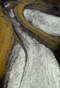
Advertisement

Moraines

Picture a glacier as a plow moving through loose soil. The soil piles up on the sides of the plow and in front of it. When you remove the plow, small ridges of soil are left. Moraines are these ridges made up from rock debris carried by the glacier.

Lateral moraines form from debris that falls off the sides of the glacier. Terminal moraines form at the end of the glacier, and can be used to determine the farthest extent of the glacier in the past.

Sheepbacks

Glacier movement can create these asymmetrical rock formations and hills. The glacier wears down the rocks gradually, forming one smooth, sloped side, but pulls r­ocks away from the other side as it passes over, forming a sharper, more jagged slope.

These formations can be used to determine the direction of glacier movement. People once thought these looked like the backs of sheep, so they called them "roche moutonnée," which is French for "sheep back."

Drumlins

Drumlins are shaped sort of like sheepbacks, except they're larger and face the opposite direction. Geologists aren't totally sure how they form. They may be similar to the ripples found in sand on the beach as water flows over it. No one is sure if they form by action of the glacier itself, or a flood that occurs as the glacier melts.

There are also horns and arêtes, which are formations of very steep rock. They form when multiple glaciers come together, carving out the rock in different areas and leaving spires of rock or steep ridges behind. Sometimes the weight of a glacier makes a part of the bedrock beneath it collapse, forming a basin known as a cirque. If the glacier melts, the cirque might become a lake.

Creators of Lakes

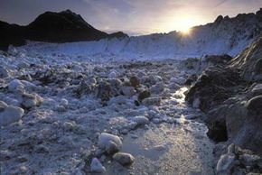
Most geologic effects of glaciation take place over thousands of years, but not all of them. A Jökulhlaup is a sudden, devastating flood that happens when a glacial lake is suddenly released. The term comes from Iceland — a place that has both volcanoes and glaciers in abundance — and originally referred to a sudden release of water by volcanic eruption.

Meltwater builds up behind some portions of glaciers, sometimes filling in to create lakes. Or, the glacier might advance across a river, damming the river and creating a lake that way. When a volcano erupts under a glacier, it might destroy an ice dam or release enormous volumes of meltwater by heat alone.

Other ice dams are destroyed by erosion, or because the lake behind them gets so high that the dam floats. Geologists use Jökulhlaup to describe all these catastrophic glacial floods, not just volcanic ones.

Near the borders of the states of Washington, Idaho and Oregon sits Glacial Lake Missoula. Geologists have determined that during past ice ages, ice dams created a lake holding over 500 cubic miles (2,084 km) of water [source: USGS]. That's about half the volume of Lake Michigan [source: IN.gov].

The ice dam eventually floated and broke apart, releasing all that water at once. The resulting deluge was probably one of the most massive floods in Earth's history. It happened several times, as the glacier crept back across the river and formed a new dam, only to break apart once the water level behind it got high enough.

Advertisement

Ice Ages and Global Warming

Columbia Glacier, Alaska
Columbia Glacier, Alaska, which has retreated more than 12 miles since the 1980s. The glacier has lost about half of its height since 1982.
Peter Essick/Aurora/Getty Images

Earth's climate isn't static. It has experienced periods of warmth and periods of extreme cold extending back hundreds of millions of years.

In fact, scientists believe that more than 500 million years ago, Earth went through several periods in which the entire planet was completely encased in ice. They refer to this as "snowball Earth" [source: Astronomy]. Eventually, volcanoes spewing carbon dioxide into the atmosphere allowed the planet to warm up.

Advertisement

Popular usage has made the term "ice age" a little confusing. In strict scientific usage, it refers to a long period (tens of millions of years) in which the Earth becomes cold enough that permanent ice sheets exist. It's thought that the Earth usually has very little permanent ice.

You're probably thinking, "Well, you just talked about Greenland ice sheets. Does that mean we're living in an ice age?" The answer is yes. We're in a cooling period that began more than 30 million years ago [source: NOVA].

Within each long ice age are periods of relative warmth, when glaciers recede, and periods when it gets colder and glaciers advance. These periods are known as interglacial and glacial, respectively. We're currently in an interglacial period. When most people refer to "the ice age," they're talking about the last glacial period.

No one is completely sure what causes these long cyclical changes in Earth's climate. It's most likely a combination of many factors:

  • Changes in the Earth's axis and orbit, known as Milankovitch cycles
  • The shifting of tectonic plates
  • Particulate matter expelled by huge volcanoes or meteor impacts blocking sunlight
  • Atmospheric composition

That last reason is the most important. Remember earlier when we mentioned that volcanoes warmed up "snowball Earth" by filling the atmosphere with carbon dioxide? It turns out that's the key to understanding our current problems with global warming.

All those prior ice ages and warming periods were caused by natural events, and they took thousands or millions of years to happen. Since the Industrial Revolution, we've been pouring carbon dioxide into the atmosphere ourselves. The result seem­s to be an increase in the temperature of the Earth that's happening far more quickly than natural processes would do alone.

Alarming Shrinkage

What does this mean for the world's glaciers? There's plenty of evidence to show that they're shrinking. Studies relying on data collected by the Gravity Recovery and Climate Experiment (GRACE) satellites spanning from 2002 to 2017, and subsequently continued by GRACE Follow-On since 2018, reveal that Antarctica lost around 150 gigatons of ice annually between 2002 and 2020. This ice loss contributed to an annual sea-level rise of 0.4 millimeters (0.02 inches) during the same period on a global scale [source: NASA].

Ice caps in the Canadian Arctic have shrunk 50 percent in the last century, and could be gone completely within decades [source: ScienceDaily]. Extensive photographic evidence shows glacial retreat worldwide [source: Nichols College]. A glacier in Peru lost 22 percent of its area in less than 40 years [source: New Scientist].

The loss of glaciers won't just raise sea levels to possibly catastrophic levels for many coastal cities. It will also accelerate global warming even further.

Large ice sheets reflect solar energy away from the Earth. The more ice we lose, the more solar energy the Earth will absorb. In addition, glaciers represent a "bank" of freshwater for many regions. Glacial meltwater is vital to human existence. The loss of these glaciers will cause severe droughts.

This article was updated in conjunction with AI technology, then fact-checked and edited by a HowStuffWorks editor.

Advertisement

Lots More Information

Related HowStuffWorks Articles

More Great Links

  • Alt, David. Glacial Lake Missoula and Its Humongous Floods. Mountain Press Publishing Company, May 1, 2001.
  • Chorlton, Windsor. Planet Earth: Ice Ages. Time-Life Books, 1983.
  • Gallant, Roy A. Glaciers. Franklin Watts, September 1999.
  • Great Lakes Information Network. “Lake Michigan Facts and Figures.” http://www.great-lakes.net/lakes/ref/michfact.html
  • Hoffman, Paul F. and Schrag, Daniel P. “Snowball Earth.” Scientific American, Jan. 2000. http://www.sciam.com/article.cfm?articleID=00027B74-C59A-1C75-9B81809EC588EF21
  • Maasch, Kirk A. “Nova: The Big Chill.” PBS. http://www.pbs.org/wgbh/nova/ice/chill.html
  • Macdougall, Douglas. Frozen Earth: The Once and Future Story of Ice Ages. University of California Press, May 2, 2006
  • National Snow and Ice Data Center. “Quick Facts.” http://nsidc.org/glaciers/quickfacts.html
  • Paleontological Research Instutition. “Formation of the Finger Lakes.” http://www.priweb.org/ed/finger_lakes/nystate_geo3.html
  • Pelto, Mauri S. and Miller, Maynard. “Terminus Behavior of Juneau Icefield Glaciers 1948-2005.” http://www.nichols.edu/departments/glacier/juneau%20icefield.htm
  • Ramanujan, Krishna. “Fastest Glacier in Greenland Doubles Speed.” NASA. http://www.nasa.gov/vision/earth/lookingatearth/jakobshavn.htm
  • Science Daily. “Antarctic Ice Loss Speeds Up, Nearly Matches Greenland Loss.” http://www.sciencedaily.com/releases/2008/01/080123181952.htm
  • Science Daily. “Baffin Island Ice Caps Shrink By 50 Percent Since 1950s, Expected To Disappear by Middle of Century.” http://www.sciencedaily.com/releases/2008/01/080128113831.htm
  • Sengupta, Somini. “Glaciers in Retreat.” New York Times, June 17, 2007. http://www.nytimes.com/2007/07/17/science/earth/17glacier.html?_r=2&oref=slogin&oref=slogin
  • United States Geographical Survey. “Glaciers and icecaps: Storehouses of freshwater.” http://ga.water.usgs.gov/edu/earthglacier.html
  • Universität Zürich. “Alpine glacier shrinkage stronger than expected.” Nov. 15, 2004. http://www.geo.unizh.ch/~fpaul/sgi/mi_en.pdf
  • University of Montana. “Speeding Glaciers: UM researchers study movement of ice rivers.” http://www.umt.edu/urelations/rview/spring06/glaciers.htm
  • University of Wisconsin, Stevens Point. “Drumlin.” http://www.uwsp.edu/geo/faculty/ritter/glossary/a_d/drumlin.html

­

Advertisement

Loading...