Here's Longest Bridge in the U.S., Plus 7 Runners-Up

By: Talon Homer  | 
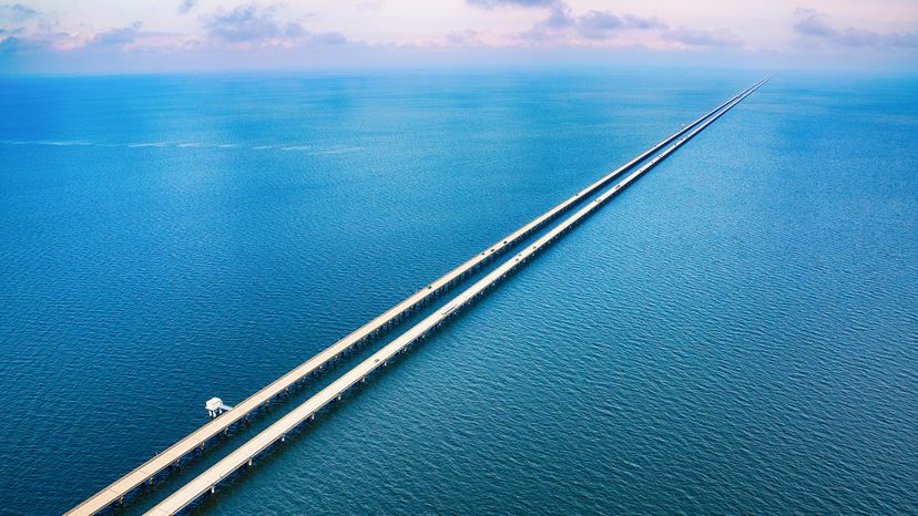
The Lake Pontchartrain Causeway spans a little less than 24 miles (38.6 km) long. Art Wager / Getty Images

Bridges are some of the most awesome and breathtaking constructions, both from a visual standpoint and from an engineering standpoint. They provide such a stark contrast with nature suspended over huge bodies of water and almost appearing to defy gravity.

When you look at the longest bridge in the U.S., it also becomes clear how incredibly complex they are to build — and build right, considering they need to both stay in the air and hold innumerable tons of vehicles and passengers every single day as their function.

Advertisement

1. Lake Pontchartrain Causeway: 23.8 Miles (38.3 km)

Southern Louisiana is home to many of the nation's longest bridges thanks to its large bodies of water and swamplands which cannot be traverse by normal roads. The Lake Pontchartrain Causeway tops them all as a mammoth roadway consisting of two parallel bridges which span the entire width of Lake Pontchartrain and connect the eastern suburbs of Baton Rouge with New Orleans, Louisiana.

Built in 1956, this bridge was known for decades as the world's longest bridge over water. This claim was verified by the Guinness Book of World Records until that title was taken by China's Jiaozhou Bay Bridge in 2011. Unlike the twin span bridge construction of the Lake Pontchartrain Causeway, the Jiaozhou Bay Bridge was built using a more complex suspension bridge design.

Advertisement

Just east of the Lake Pontchartrain Causeway is another fairly long (though less impressive) bridge which crosses Lake Pontchartrain. The Norfolk Southern Lake Pontchartrain Bridge covers 5.8 miles (9.3 km) of water and provides Amtrak rail service for passengers through southern Louisiana.

2. Manchac Swamp Bridge: 23 Miles (37 km)

Just a few miles west of the Lake Pontchartrain Causeway is another set of parallel bridges which nearly matches it in length.

As its name suggests the Manchac Swamp Bridge crosses 23 miles (37 km) of wetlands through the Louisiana bayou and just a sliver Lake Maurepas' body of water. This impressive highway bridge was constructed in 1979.

Advertisement

3. Atchafalaya Basin Bridge: 18.2 Miles (29.3 km)

Yet another length bridge located in the bayou, this 18-mile-long highway (also known as the Louisiana Airborne Memorial Bridge) connects the cities of Lafayette and Baton Rouge while covering the swamp land of the Atchafalaya forest.

The Atchafalaya Basin Bridge, built in 1973, is a bit older than our last entry.

Advertisement

4. Chesapeake Bay Bridge Tunnel: 17.6 Miles (28.3 km)

One of the most impressive bridges in the U.S. from an engineering standpoint, the Chesapeake Bay Bridge Tunnel crosses a 17.6-mile (28.3-km) span from Virginia Beach up to Cape Charles, Virginia, and the surround archipelago.

The expressway not only crosses water, but dips underground through two 1-mile (1.6-km) sections in order to increase its structural integrity. This opened in 1964 with a significant expansion project carried out in 1999.

Advertisement

5. Bonnet Carré Spillway Bridge: 11 Miles (17.7 km)

This bridge built in 1972 is just west of New Orleans and runs parallel to the waters of Lake Pontchartrain to the north and LaBranche wetlands to the south.

The 11-mile (17.7 km) Bonnet Carre Spillway Bridge gets its name from an important piece of infrastructure tasked with diverting floodwater away from the city of New Orleans during a hurricane or other large storm.

Advertisement

6. Louisiana Highway 1 Bridge: 8.3 Miles (13.4 km)

Located at the very tip of southeastern Louisiana, this bridge spans 8.3 miles (13.4 km) of Bayou Lafourche and is one of the few roads that makes more remote areas of the swampland accessible. The Louisiana Highway 1 Bridge is also one of the newest projects featured here, as the bridge opened for business in 2009.

Advertisement

7. Jubilee Parkway: 7.5 Miles (12.1 km)

Located due east of Mobile, Alabama, the seventh-longest bridge in the United States crosses 7.5 miles (12.1 km) over the northern tip of Mobile Bay and heads toward the state's southern shore and then to neighboring Florida.

This bridge is interesting because it runs alongside another bridge called Battleship Parkway, and they even cross over each other about halfway into their spans. The roadway opened in 1978, and oddly, it was originally named "America's Junior Miss Byway" as a sponsorship tie-in with a local beauty pageant in Mobile.

Advertisement

8. San Mateo-Hayward Bridge: 7 Miles (11.3 km)

When navigating California's Bay Area, San Francisco and the peninsula where it sits is only accessible via the area's four large bridges:

  • The Golden Gate Bridge, connecting with Sausalito to the north
  • The Bay Bridge, connecting with Oakland to the east
  • The San Mateo-Hayward Bridge, south of San Francisco proper and connecting with Hayward to the east
  • The Dumbarton Bridge, touching on Silicon Valley (even farther south of SF) and connecting Redwood City and Palo Alto with Newark

The most recognizable and iconic of these is, of course, the Golden Gate Bridge at the northern gulf of the city. But at 1.7 miles (2.7 km) the Golden Gate is far from the longest design. That title falls to the San Mateo-Hayward Bridge, which spans just over 7 miles (11.3 km) across San Francisco Bay.

Advertisement

This straight shot across the bay helps connect the San Francisco Peninsula with both Fremont and Oakland, as well as gorgeous nature preserves in the area. The San Mateo Bridge opened in 1967 and immediately became the longest bridge in California, a title which it holds to this day.

Advertisement

Advertisement

Loading...