How Tsunamis Work

By: Robert Valdes, Nathan Halabrin & Robert Lamb
The shore of Banda Aceh, Sumatra, before and after the 2004 tsunami.
Photo courtesy DigitalGlobe

On March 11, 2011, a magnitude 9.0 earthquake struck off the coast of Honshu, Japan, sparking a tsunami that not only devastated the island nation, but also caused destruction and fatalities in other parts of the world, including Pacific islands and the U.S. West Coast.

Initial reports were eerily similar to those on Dec. 26, 2004, when a massive underwater earthquake off the coast of Indonesia's Sumatra Island rattled the Earth in its orbit.

Advertisement

The 2004 quake, with a magnitude of 9.1, was the largest one since 1964. But as in Japan, the most powerful and destructive aftermath of this massive earthquake was the tsunami that it caused. The death toll reached higher than 220,000, and many communities suffered extensive property damage.

Scientifically speaking, both of these disasters -- which overshadow other tsunamis in recent history -- followed the same basic sequence of events. In this article, we'll look at what causes tsunamis, the physics that drives them and the effects of a tsunami strike. We'll also examine scientists' worldwide efforts to monitor and predict tsunamis in order to avoid disasters like the one that occurred in the final days of 2004 -- efforts that may have helped save lives in March of 2011.

Find out more about how to classify waves on the next page.

Classifying Waves

Tsunamis differ from regular waves on several fronts, besides size.
HowStuffWorks.com

The word "tsunami" comes from the Japanese words tsu (harbor) and nami (waves). A tsunami is a wave or series of waves in the ocean that can span hundreds of miles across and reach heights of 100 feet (30 meters) and more once they near land. These "walls of water" can even outrun a commercial jet. The massive Dec. 26, 2004, tsunami traveled 375 miles (600 kilometers) in a mere 75 minutes. That's 300 miles (480 kilometers) per hour. When these walls of water hit coastal lands, massive damage often occurs.

In order to understand tsunamis, let's first look at waves in general. Most of us are familiar with waves from days at the beach or at local wave pools. Waves consist of a crest (the highest point of the wave) and a trough (the lowest point of the wave). We measure waves in two ways:

Advertisement

  1. The wave height is the distance between the crest and trough.
  2. The wavelength is the horizontal distance between two consecutive wave crests.

We measure the frequency of waves by noting the time it takes for two consecutive waves to cross the same point. This is called the wave period.

So as far as structure goes, tsunamis and normal waves are the same. The differences boil down to sheer magnitude and speed, as the accompanying table describes.

Now let's look at what creates a normal wave. Waves in the ocean stem from several different factors such as gravitational pull, underwater activity and atmospheric pressure. The most common source for waves, however, is wind.

When the wind blows across a smooth water surface, the air molecules grab water molecules as they speed along. The friction between the air and water stretches the water's surface, creating ripples in the water known as capillary waves. The capillary waves move in circles. This circular motion of water continues vertically underwater, though the power of this motion decreases in deeper water. As the wave travels, more water molecules amass, increasing the size and momentum of the wave. The most important thing to know about waves is that they do not represent the movement of water, but instead show the movement of energy through water.

In normal waves, the wind is the source of that energy. The size and speed of wind waves depends on the strength of what's blowing.

The Birth of a Tsunami

Formation of a tsunami

Underwater earthquakes are the most common tsunami instigator. To understand them, we have to delve into plate tectonics, which suggests that a series of huge plates makes up the lithosphere, or top layer of the Earth. These plates make up the continents and seafloor. They rest on an underlying viscous layer called the asthenosphere.

Think of a pie cut into eight slices. The piecrust would be the lithosphere and the hot, sticky pie filling underneath would be the asthenosphere. On the Earth, these plates are constantly in motion, moving along each other at a speed of 1 to 2 inches (2.5 to 5 centimeters) per year. The movement occurs most dramatically along fault lines (where the pie is cut). These motions can produce earthquakes and volcanism, which, when they occur at the bottom of the ocean, are two possible sources of tsunamis.

Advertisement

When two plates come into contact at a region known as a plate boundary, a heavier plate can slip under a lighter one. This is called subduction. Underwater subduction often leaves enormous "handprints" in the form of deep ocean trenches along the seafloor.

In some cases of subduction, part of the seafloor connected to the lighter plate may "snap up" suddenly due to pressure from the sinking plate. This results in an earthquake. The focus of the earthquake is the point within the Earth where the rupture first occurs, rocks break and the first seismic waves generate. The epicenter is the point on the seafloor (or other part of the Earth's surface) directly above the focus.

When this piece of the plate snaps up and sends tons of rock shooting upward with tremendous force, the energy of that force transfers to the water. The energy pushes the water upward above normal sea level. This is the birth of a tsunami. The earthquake that generated the Dec. 26, 2004, tsunami in the Indian Ocean had a magnitude of 9.1 -- one of the biggest in recorded history.

Hitting the Water

Once the water pushes upward, gravity acts on it, forcing the energy out horizontally along the surface of the water. It's sort of the same ripple effect you get from throwing a pebble in the water except the energy is generated by a force moving out of the water rather than into it. The energy then travels through the depths and away from the initial disturbance.

The tremendous force created by the seismic disturbance generates the tsunami's incredible speed. We calculate the actual speed of the tsunami by measuring the water depth at a point in time when the tsunami passes by.

Advertisement

A tsunami's ability to maintain speed is directly influenced by the depth of the water. A tsunami moves faster in deeper water and slower in shallower water. So unlike a normal wave, the driving energy of a tsunami moves through the water as opposed to on top of it. Therefore, as a tsunami moves though deep water at hundreds of miles an hour, it is barely noticeable above the waterline. A tsunami is typically no more than 3 feet (1 meter) high until it gets close to shore.

Once a tsunami gets close to shore, it takes its more recognizable and deadly form.

When a Tsunami Makes Landfall

Wreckage of a political party clubhouse from a tsunami that hit the Aleutian Islands in 1946
Photo courtesy National Geophysical Data Center

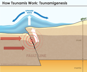
When a tsunami reaches land, it hits shallower water. The shallow water and coastal land acts to compress the energy traveling through the water. And the terrible transformation of the tsunami begins.

The topography of the seafloor and shape of the shore affects the tsunami's appearance and behavior. In addition, as the velocity of the wave diminishes, the wave height increases considerably. This compressed energy forces the water upward.

Advertisement

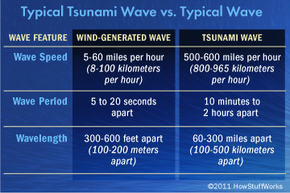
A typical tsunami approaching land will slow down to speeds around 30 miles (50 kilometers) per hour, and the wave heights can reach up to 100 feet (30 meters) above sea level. As the wave heights increase during this process, the wavelengths shorten considerably. Imagine squeezing an accordion and you get the general idea.

A witness on the beach will see a noticeable rise and fall of beach water when a tsunami is imminent. Sometimes, the coastal water will drain away completely as the tsunami approaches. This stunning sight is followed by the actual trough of the tsunami reaching shore.

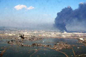
Contrary to what you may have seen in Hollywood disaster films, tsunamis usually arrive as a series of swift, powerful floods of water, not as a single, enormous wave. However, a large vertical wave called a bore may come with a churning front. Rapid floods of water often follow bores, making them particularly destructive. Other waves can follow anywhere from five to 90 minutes after the initial strike. The tsunami wave train, after traveling as a series of waves over a long distance, crashes into the shore.

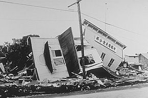
Tsunamis typically result in staggering body counts. This is especially true when they strike without warning. Tsunamis can level development and strip away coastlines, pulling everything in their path out to sea.

The areas of greatest risk during a tsunami strike are within 1 mile (1.6 kilometers) of the shoreline, due to the flooding and scattered debris, and less than 50 feet (15 meters) above sea level, due to the height of the striking waves.

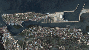
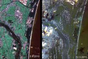
A tsunami can even affect sheltered areas if varying land features and the underlying seascape line up just right. For instance, a protected bay area with a narrow inlet can give a tsunami a "funnel" to travel through, amplifying the destructive power of the waves. River channels can also provide room for a tsunami bore to rush through and flood vast tracts of land.

Until a tsunami strikes, it's difficult to predict how it will interact with the features of the affected land. The wraparound effect occurs along island coastlines when multiple wave strikes hit different areas of surrounding land, resulting in different degrees of flooding. Harbor resonance is a chaotic and highly destructive tsunami side effect created when waves continuously reflect and bounce off the edges of a harbor or bay. Harbor resonance can cause the amplification of circulating wave heights and even increase the duration of the wave activity within the area.

2004 and 2011 Tsunamis

An aerial view of tsunami and earthquake damage off the coast of Northern Japan as seen from a U.S. Navy helicopter on March 12, 2011.
Photo by U.S. Navy via Getty Images

On Dec. 26, 2004, the world's most powerful earthquake in more than 40 years struck deep under the Indian Ocean off the west coast of Sumatra. The massive 9.1 magnitude quake even shook buildings in Bangkok, Thailand 1,242 miles (nearly 2,000 kilometers) from where the earthquake took place. According to the U.S. Geological Survey, the underwater quake hit with the power of 23,000 Hiroshima-type atomic bombs.

A massive and particularly deadly tsunami ensued. One of the factors that made this event particularly destructive was that the tsunamis struck relatively well-populated areas in the middle of the tourist-packed holiday season. The waves slammed into 11 Indian Ocean countries, killing an estimated 220,000 people and displacing millions [source: National Geographic].

Advertisement

On March 11, 2011, a 9.0 earthquake occurred, this time near the east coast of Honshu, Japan. Like the 2004 underwater earthquake, this too unleashed a massive tsunami. The waves completely obliterated such coastal towns as Kuji and Ōfunato and severely damaged much of the infrastructure in eastern Sendai. Within a week of the incident, the death toll had risen to 4,164, with 7,843 reported missing and 2,218 injured [source: CNN].

Tragedy swelled into crisis, however, as the tsunami also destroyed the generators required to circulate water through the nuclear reactor at the Fukushima-Daiichi facility. The reactor shut down with 10 minutes of increased seismic activity, but it still required an operable cooling system to prevent dangerous increases in core temperature from decay heat in the radioactive core.

Water temperature and pressure continued to rise and radiation began to split the water into hydrogen and oxygen. Hydrogen explosions breached the reactor building's steel containment panels. Japanese authorities were now faced with the challenge of cooling the Fukushima-Daiichi and stopping the leak of deadly radiation from the crippled facility.

The ravages of a powerful tsunami can be truly catastrophic. On the next page, we'll learn what can be done to predict their formation.

Predicting a Tsunami

These images show the effects of the tsunami on Japan's coastline. The image on the left was taken on Sept. 5, 2010; the image on the right was taken on March 12, 2011, one day after an earthquake and resulting tsunami struck the island nation.
Image courtesy NASA/German Aerospace Center/Rapid Eye

Scientists are constantly trying to learn new ways to predict the behavior of tsunamis. Given current technology however, most tsunami data come to us after the damage has already occurred.

In a post-tsunami survey, geologists measure a number of factors. Scientists are particularly interested in the inundation and run-up features after the waves strike land. Inundation is the maximum horizontal distance penetrated inland. Run-up refers to the maximum vertical distance above sea level that the waves reached. Inundation and run-up are often determined by measuring the distance of killed vegetation, scattered debris along the land and eyewitness accounts of the incident.

Advertisement

Scientists have made great strides in monitoring and predicting the ongoing threat of tsunamis. One center continuously monitoring seismic events and changes in the tide level is the Pacific Tsunami Warning Center (PTWC). The center is located in Ewa Beach, Hawaii, and services the Hawaiian Islands and surrounding U.S. territories by working in conjunction with other regional centers. The West Coast & Alaska Tsunami Warning Center (ATWC) in Palmer, Alaska, serves the Aleutian Islands area along with British Columbia, Washington state, Oregon and California. This center is of particular importance because submarine earthquakes in this region have created waves that moved throughout the Pacific Ocean before striking elsewhere.

Tsunamis are detected by open-ocean buoys and coastal tide gauges, which report information to stations within the region. Tide stations measure minute changes in sea level, and seismograph stations record earthquake activity. A tsunami watch goes into effect if a center detects an earthquake of magnitude 7.5 or higher. Civil defense agencies are then notified, and data from tidal gauge stations are closely monitored. If a threatening tsunami passes through and sets off the gauge stations, a tsunami warning issues to all potentially affected areas. Evacuation procedures in these areas are then implemented.

The Deep-Ocean Assessment and Reporting of Tsunamis (DART) uses unique pressure recorders that sit on the ocean bottom. These recorders are used to detect slight changes in the overlying water pressure. The DART system can detect a tsunami as small as a centimeter high above the sea level.

NASA is also heavily involved in the quest to predict deadly tsunamis before the occur. In 2010, researchers at NASA's Jet Propulsion Laboratory successfully demonstrated elements of a prototype tsunami prediction system. Using real-time data from the agency's Global Differential GPS (GDGPS) network, the system successfully predicted the size of the tsunami following the Feb. 27, 2010, Chilean earthquake. In the future, such a system may enable more effective advance warning of incoming waves. In the instance of the 2011 Japan tsunami, the warning systems worked fine. Rather it was the unanticipated size of the event that proved so deadly.

That leads us to the biggest problem with tsunamis: Once in motion, they can't be stopped. Scientists and civil agencies can only devote resources to predicting tsunamis and creating effective plans for protecting coastal areas from their ravages.

For more information on tsunamis and related topics, explore the links on the next page.

Lots More Information

Related Articles

More Great Links

  • "The Deadliest Tsunami in History?" National Geographic News. Jan. 7, 2005. (March 17, 2011)http://news.nationalgeographic.com/news/2004/12/1227_041226_tsunami.html
  • "Japan quake live blog: 'Extremely high' radiation at Japan plant, U.S. agency says." CNN. March 16, 2011. (March 17, 2011)http://news.blogs.cnn.com/2011/03/16/japan-quake-live-blog-death-toll-expected-to-rise-as-crews-reach-more-areas/?hpt=T1
  • "Magnitude 9.0 - NEAR THE EAST COAST OF HONSHU, JAPAN." United States Geological Survey. March 11, 2011. (March 17, 2011)http://earthquake.usgs.gov/earthquakes/eqinthenews/2011/usc0001xgp/