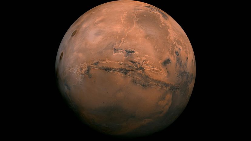
Mars is a dusty, cold, desert world with a very thin atmosphere. But evidence suggests billions of years ago, Mars was wetter and warmer, and had a thick atmosphere. NASA/JPL-Caltech
Since the earliest days of astronomy, people have been fascinated by Mars. Something about the Red Planet invites wide-eyed speculation — and now the urge to explore Mars, too.
Space agencies started sending unmanned missions to Mars during the Cold War. Several countries, including the United States, Russia, Japan and China have dispatched "orbiters," "rovers" or "landers" to study our neighbor in the solar system.
Advertisement
One of those missions — the Mariner 4 flyby Uncle Sam launched in 1964 — gave us the first photos of another planet that were ever taken by a camera sent into outer space. And that was just the first spacecraft of many to orbit, flyby and even land on the Martian surface.
So what have scientists learned about Mars from the data gleaned from these missions? And when might the machines on Mars get human company? Will humans ever set foot on the Red Planet?
Nobody's quite sure but at least you can read up on all things Mars while you wait.
Get ready future astronauts because today we're talking Mars. How did it form? What's the weather like? What is the planet's surface composed of? And perhaps most importantly, did Martian soil ever have water or support life?
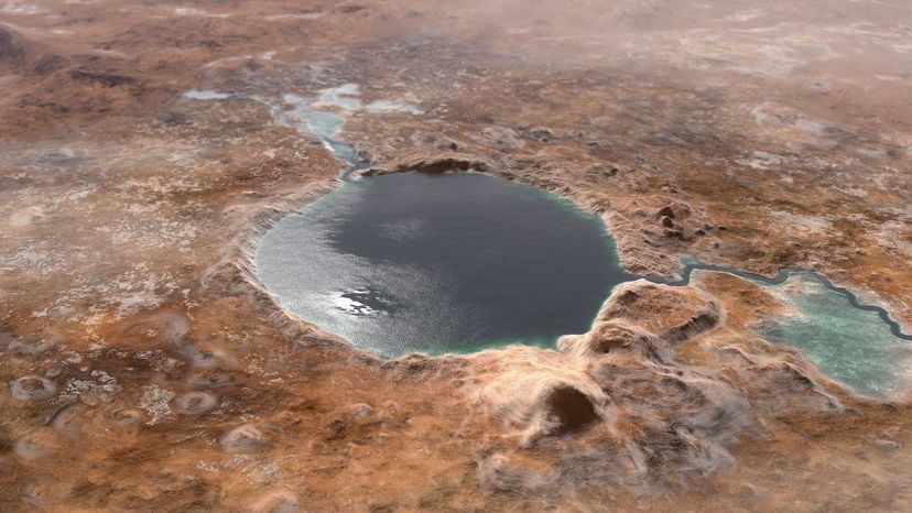
This illustration shows Jezero Crater — the landing site of the Mars 2020 Perseverance rover — as it may have looked billions of years go on Mars, when it was a lake. NASA/JPL-Caltech
No human has ever been to Mars. So the best information that we have about ancient Mars' beginnings 4.6 billion years ago generally comes from Martian meteorites, images taken by Mars orbiters and landers, and comparisons with other planets in the solar system like Mercury, Venus, Earth — and Earth's moon, for good measure.
Scientists think Mars originally formed in the ancient past from an accumulation of spacefaring gas and dust, brought together by gravity.
Advertisement
Modern Earth has a magnetic field called a "magnetosphere" that protects us from the worst effects of solar wind. Mars once had a strong magnetosphere of its own, but it's been substantially weakened over geologic time. This could help explain why the planet's surface looks so desolate today. We'll put a pin in that topic for now.
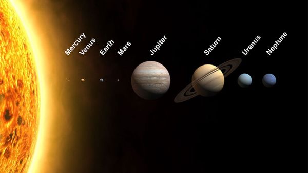
Mars has an equatorial radius of 2,098 miles (3,396.2 kilometers). That makes the Red Planet about half the size of Earth, and it's just 71 percent as dense as our home planet, to boot. Even so, Mars has one more moon than Earth.
The two natural satellites currently revolving around Mars are called Deimos and Phobos, after a pair of mythic horses belonging to the Greek god, Ares.
On average, Mars sits 142 million miles (228 million kilometers) away from the sun. A day on Mars lasts for 23.9 of our Earthling hours, while a Martian year drags on for the equivalent of 687 Earth days.
Assuming you ever get to take a vacation on Mars (don't forget to write), what's there to see on the planet's rocky face? Glad you asked.
Advertisement
The Martian Surface
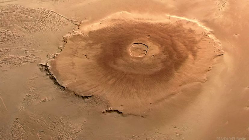
Olympus Mons is three times higher than Earth's Mount Everest and the largest volcano in our solar system. ESA, DLR, FU Berlin, Mars Express; Processing & CC BY 2.0 License: Andrea Luck
The Southern Hemisphere of Mars is dominated by elevated highlands. Heavily cratered like Earth's moon, they're very different from the flatter, smoother terrain we see in the planet's Northern Hemisphere. As the European Space Agency (ESA) reports on its official website, the "Northern Hemisphere [of Mars] is... on average, 6 kilometers [3.72 miles] lower than the rugged highlands of the south."
Mars may be a smaller planet than Earth, but its geological features are king-sized.
Advertisement
The tallest mountain in the solar system that we know about occupies the planet's Western Hemisphere. Called Olympus Mons (in honor of Mount Olympus from Greek mythology), this shield volcano towers 16 miles (25 kilometers) above the surrounding plains, and its base spans 374 miles (624 kilometers).
Olympus Mons is comparable in overall size to the state of Arizona. And it's roughly 100 times larger than Hawaii's Mauna Loa, which is currently the biggest active volcano on Earth at 30,085 feet (9,170 meters). Olympus Mons could still be active, though other parts of the Red Planet's surface are dotted with extinct volcanoes.
Then there's Valles Marineris. It's the largest canyon in the solar system and it cuts a jagged gorge across the surface of Mars that's more than 1,864 miles (3,000 kilometers) long and 372 miles (600 kilometers) across. For reference, the distance from Atlanta to Los Angeles is about 2,187 miles (3,519 kilometers). The canyon is also up to 4.3 miles (8 kilometers) deep.
Other notable features on the Martian surface include the twin polar ice caps. The ice cap at the North Pole is called Planum Boreum, and the ice cap at the South Pole is named Planum Australe. Both contain a mixture of frozen carbon dioxide (dry ice) and water ice.
Mars has an axial tilt that causes it to experience seasons. The size of the polar ice caps varies with the seasons. In the summer, the solid carbon dioxide is converted into vapor, revealing a sheet of water ice below.
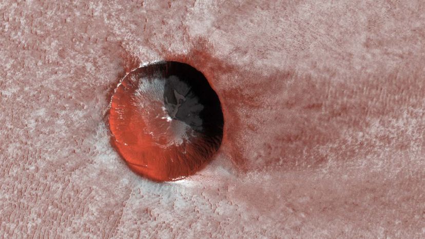
NASA's Mars Reconnaissance Orbiter captured this ice-filled crater near the North Pole of Mars in December 2019. This crater is about 650 feet (200 meters) across.
NASA/JPL/University of Arizona
Advertisement
The Interior of Planet Mars
Mars, like Earth, has a dense inner core. Thought to measure 930 to 1,300 miles (1,500 to 2,100 kilometers) around its radius, this layer contains nickel, sulfur and iron.
The core is enveloped by a series of other layers, with the outermost being the Martian crust. Made up of such ingredients as aluminum, iron, potassium, magnesium and calcium, this crust is up to 1,170 miles (1,880 kilometers) thick.
Advertisement
Earth's own crust is split into regions called tectonic plates. They're on the move, despite outward appearances to the contrary, and their interactions have a dramatic influence on our planet. Tectonic activity at or near areas of contact between the plates is the driving force behind earthquakes and volcanic activity. It's also why the layout of our continents shifts over tens of millions of years.
OK, so what about Mars? Scientists think some kind of tectonic mechanism — or mechanisms — could have forged the Valles Marineris canyon system and the mighty plateaus of the planet's southern highlands.
They're still trying to figure out how geologic activity works on modern Mars. The Red Planet doesn't seem to have an Earth-style plate tectonics system. Yet the InSight Mars Lander (a technical marvel made possible by an international spacefaring effort) has recorded more than 1,300 seismic "quakes" on Mars since the vehicle arrived there in 2018.
After learning all that, do you still want to see this planet for yourself? You might have difficulty breathing on Mars. Find out why next.
Advertisement
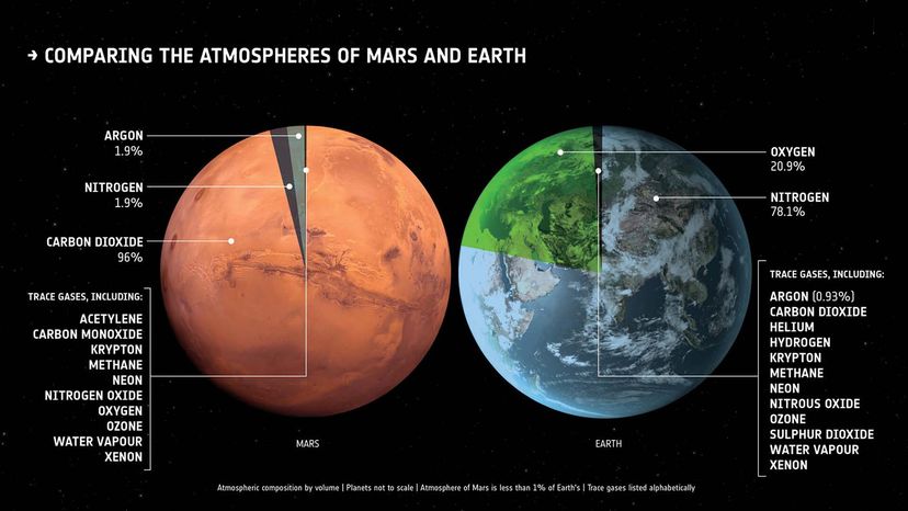
Mars Has a Thin Atmosphere
Mars has an extremely thin atmosphere, though at one time it was likely much thicker. European Space Agency
It may not be as hellish as Venus, but the fourth planet from the sun still isn't what most people would call hospitable. The atmosphere on Mars differs from Earth's in many ways, and most of them don't bode well for humans living there.
Composed mostly of carbon dioxide (the gas represents more than 95 percent of the Martian atmosphere by volume), the atmosphere on Mars is remarkably thin and loaded with drifting dust particles. Scientists do think Mars once had a thicker atmosphere. Data from NASA's Mars Atmosphere and Volatile Evolution (MAVEN) mission suggests Mars has lost most of its atmosphere to solar wind and ultraviolet rays.
Advertisement
Extreme cold is another issue Martian settlers would have to contend with. Temperatures on the Red Planet bottom out at minus 200 degrees Fahrenheit (minus 128 degrees Celsius). The U.S. National Atmospheric and Space Administration (NASA) has recorded highs of up to 86 degrees Fahrenheit (30 degrees Celsius) around the equator, but such conditions are rare. The planet's average temperature is closer to minus 81 degrees Fahrenheit (minus 60 degrees Celsius).
So maybe it's not too surprising that, sometimes, it snows on Mars. And we're not just talking about the plain old "water snow" we get on Earth. Mars gets that, too, make no mistake. But something far more remarkable happens on the Martian surface as well.
As found by NASA's Mars Reconnaissance Orbiter, during the Martian winter, carbon dioxide from the polar areas refreezes and falls from the atmosphere as carbon dioxide snow.
And carbon dioxide snow isn't the only kind of strange weather on Mars. Those who've seen "The Martian" are probably aware of the legendary dust storms that can envelope the Red Planet.
You'd be most likely to face one of these in the Southern Hemisphere, during the warmer months.
The nastiest of dust storms are global in scale, spreading across huge regions of the planet and might rage on for weeks at a time. All that dust can be bad for the rovers traversing the surface, especially when flying dust smothers their solar panels.
Some of these drastic temperature variations can also be blamed on Mars' orbit. As we mentioned, it takes Mars about 687 Earth days to complete its orbit. Its axis is tilted 25 degrees, nearly the same as Earth, which also gives Mars seasons similar to the ones we have on Earth.
As Mars travels along this orbital path, it moves slower when it is furthest from the sun and faster when it is closest to the sun. This also means Mars has a longer solar day (about 24 hours and 39 minutes) than our 24-hour day on Earth. One Martian year is also much longer than one Earth year.
Gravity-wise, Mars might give you a whole new perspective on bathroom scales. A 100-pound (45.35-kilogram) person would weigh a meager 38 pounds (17.2 kilogram) on Mars; the gravity on the Martian surface is 62 percent lower than it is on Earth at sea level.
Advertisement
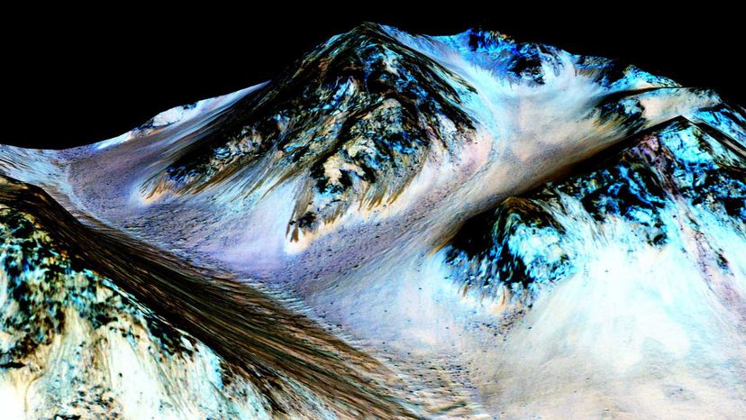
Water on Mars
The dark, narrow streaks seen flowing downhill in the image above are called recurring slope lineae. They're are thought to have been formed by flowing water on Mars. NASA/JPL/University of Arizona
Liquid water is essential for life, including microbial life. At least that's the case here on Earth and presumably, the same goes for arid Mars.
That's the assumption that governed NASA's "follow the water" strategy for Mars exploration.
Advertisement
Scientists don't think liquid water was always so scarce on Mars. Modern Mars may resemble a barren desert, but ancient Mars may have been quite wet, judging from some of the geologic clues left behind. Floods may once have flowed over the planet's surface, rivers may have carved out channels or gullies, and lakes and oceans may have covered large swaths of the planet.
And what of those Martian polar ice caps? New research, including data from the European Space Agency Mars Express mission, indicates that, contrary to what some scientists had previously argued, there may be subsurface lakes full of liquid water hidden beneath the solid ice at the poles.
The jury is still out on that one. But would-be space settlers of the future, keep your fingers crossed. Maybe someday, sooner than we realize, Martian water-miner could be a totally legitimate job description.
Advertisement
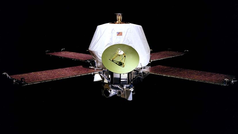
Mars Exploration
Mariner 9 became the first spacecraft to orbit another planet when it orbited Mars in 1971. NASA
The closest Mars ever gets to Earth is when it's in opposition, meaning when the two planets come nearest to each other in their orbits. And close is still relative here because the two planets are still 33.9 million miles (54.6 million kilometers) apart. But Mars is the most explored of all the planets in the solar system.
In 1971, the Mariner 9 became the first spacecraft to orbit another planet when it mapped 85 percent of the Martian surface. The mission sent back tons pictures, including images of Olympus Mons, Valles Marineris, and the Martian moons Phobos and Deimos.
Advertisement
But it's the rovers and landers that have provided the best information to date, including the dizzying amount of data from Curiosity and Perseverance.
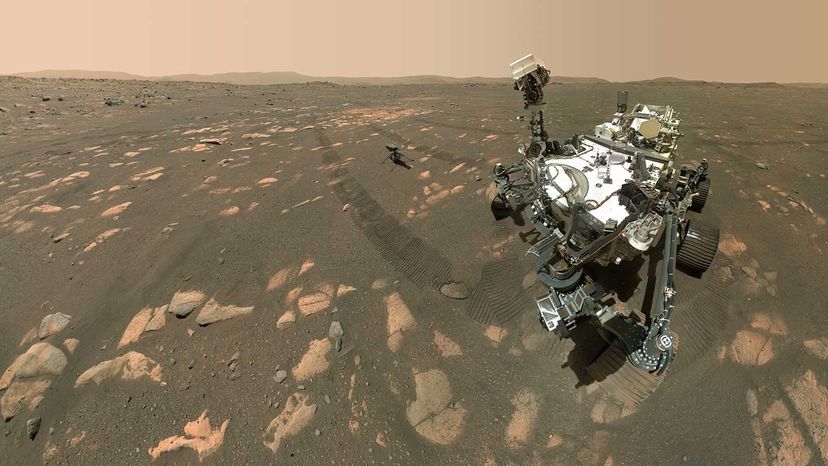
Perseverance Rover
NASA’s Perseverance Rover took this selfie with the Ingenuity helicopter, seen here about 13 feet (3.9 meters) from the rover, April 6, 2021.
NASA/JPL-Caltech/MSSS
The Perseverance Rover is part of NASA's Mars Exploration Program, which is tasked to find, among other things, if there is microbial life on Mars. Perseverance has been cruising around on the surface of Mars for more than two years. It can drill into the Martian soil to collect samples of rocks that will one day be sent back to Earth to be studied by scientists. Some rock samples Perseverance drilled near the Jezero Crater appear to be volcanic in origin.
Nicknamed Percy, the rover arrived at the Jezero Crater Feb. 18, 2021, with a special helicopter named Ingenuity along for the ride. To date, Ingenuity has spent 91.4 flying minutes — divided between 51 individual flights — navigating the Martian atmosphere and its environmental conditions.
Perseverance continues the work of the Curiosity Rover, which has been on Mars since 2012, and others like the Spirit and Opportunity rovers, and the Sojourner Rover.
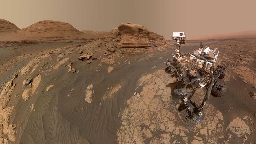
Curiosity Rover
NASA’s Curiosity Rover used two different cameras to create this selfie in front of Mont Mercou, a rock outcrop that stands 20 feet (6 meters) tall.
NASA/JPL-Caltech/MSSS
The Curiosity Rover is one of NASA's most ambitious missions to explore Mars. The rover is about the size of a small SUV and measures about 9.5 feet (2.9 meters) in length and 8.9 feet (2.7 meters) in width. Its size means it also has the largest and most advanced instruments for scientific studies on the Martian surface.
Curiosity Rover landed in the Gale Crater Aug. 6, 2012, with a mission to determine if the conditions on Mars can support microbial life, or if the planet could have at one time supported life.
Curiosity collected the first samples ever drilled from rocks on Mars. Analysis of that sample suggested conditions on Mars may have once been able to support Martian life.
Since 2014, Curiosity has been traversing the surface and collecting several samples of rocks and Martian soil from geological features like Mount Sharp. Mount Sharp is a 3-mile-tall (5-kilometer-tall) mountain once covered in water. Evidence suggests the Gale Crater where Mount Sharp is located (and Mars in general) is an environment where life could have once survived.
This article was updated in conjunction with AI technology, then fact-checked and edited by a HowStuffWorks editor.
Now That's Interesting
Mars appears bright the night sky when the Red Planet and Earth are at their closest, and is also one planet relatively easy to see with the naked eye. The next time the Red Planet and Earth will be on a close approach is Jan. 12, 2025.
Advertisement
Mars FAQ
How big is Mars?
Mars has an equatorial radius of 2,098 miles (3,396.2 kilometers). That makes the Red Planet about half the size of Earth, and it's just 71 percent as dense as our home planet.
Is Mars hot or cold?
Mars is cold (to us at least). The average surface temperature of Mars is minus 81 degrees Fahrenheit (minus 63 degrees Celsius).
Why is Mars called the Red Planet?
Mars is called the Red Planet because the soil on Mars has a rust-colored, reddish tint.
Can humans live on Mars?
Mars is not habitable by humans because the atmosphere differs greatly from Earth's. It's composed mostly of carbon dioxide, has much less nitrogen and very little oxygen.
Is the temperature on Mars hot or cold?
Mars is quite a cold planet with less of an atmosphere than Earth, and it has a difficult time holding heat. The average surface temperature on Mars is minus 81 degrees Fahrenheit (minus 63 degrees Celsius).
Cite This!
Please copy/paste the following text to properly cite this HowStuffWorks.com article: