How Does a Hurricane Form? Exploring the Science of Storm Formation

By: HowStuffWorks  | 
how does a hurricane form
Hurricanes release energy through condensation, further intensifying the storm's strength. Stocktrek Images / Getty Images/Stocktrek Images

Have you ever wondered what makes hurricanes so powerful and destructive? From their formation to their devastating impacts, hurricanes are complex and fascinating natural phenomena. In this blog post, we’re going to explore the science behind how a hurricane forms, the factors that influence their development, and the tools used by meteorologists to track and predict their movements.

Short Summary

  • Hurricanes are powerful storms that form in warm ocean waters, low air pressure and tropical waves.
  • Meteorologists use satellite observations, hurricane hunter aircraft and computer forecasting models to track and predict hurricanes.
  • Notable Hurricanes such as Katrina have caused immense destruction with billions of dollars in damage and multiple fatalities.

Advertisement

The Birth of a Hurricane: Tropical Disturbances and Waves

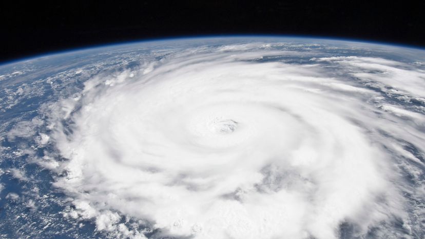
Hurricane formation is a complex process that begins with a series of initial stages, including tropical disturbances and waves. These disturbances are storms originating in tropical oceans, powered by warm water, and possessing intricate weather systems that vary in intensity, size, and other characteristics, such as wind speeds. This is how hurricanes form.

The elements crucial for the formation of tropical cyclones are warm ocean waters, low air pressure, and tropical waves. Let’s delve deeper into these factors and their roles in hurricane formation.

Advertisement

Warm Ocean Waters

Warm ocean waters play a critical role in providing energy for storm development. The temperature of the upper 60 meters of the ocean water must be greater than 26°C (79°F) for a tropical cyclone to form. That is the ideal condition for a cyclone’s formation. This warmth creates the necessary conditions for warm air to rise and fuel the storm.

As the storm intensifies, wind speeds increase; once they reach 39 miles per hour, the storm is designated a name.

Low Air Pressure

Low air pressure is another essential factor in the development of a tropical disturbance. It causes warm air to rise from the ocean, carrying hot, humid air in a spiral pattern, contributing to the growth of the disturbance.

The winds blowing westward across the Atlantic from Africa are integral to the formation of a tropical cyclone, and low wind shear, heat, and moisture are essential for continued development.

Tropical Waves

Tropical waves are low-pressure systems that traverse moist tropical regions. They play a vital role in initiating hurricane formation, as they can cause areas of low pressure that can develop into tropical disturbances.

When a tropical disturbance intensifies and exhibits a circular wind flow with maximum sustained winds below 39 mph, it becomes a tropical depression.

Advertisement

The Evolution of a Storm: From Tropical Depression to Hurricane

As a storm progresses from a tropical depression to a full-blown hurricane, it undergoes several stages of development, including:

  1. Tropical disturbance
  2. Tropical depression
  3. Tropical storm
  4. Full-fledged tropical cyclone

The distinction between these stages is primarily determined by wind speed.

Advertisement

Let’s explore each stage in more detail and understand how a storm evolves into a powerful hurricane.

Tropical Depression

A tropical depression is characterized by:

  • A circular wind flow
  • Maximum sustained winds below 39 mph
  • Thunderstorms
  • A low-pressure system

At this stage, the storm is relatively weak, but it has the potential to grow and become more destructive as it gathers energy from warm ocean waters.

As the storm moves over warm ocean waters, it can gain strength and become a tropical storm.

Tropical Cyclone

When a tropical depression intensifies, and its wind speeds reach at least 39 miles per hour, it becomes a tropical cyclone. The storm gains strength by utilizing the energy derived from warm ocean waters, as well as releasing latent heat of condensation when the air rises and cools.

As the tropical cyclone continues to strengthen, it poses an increasing threat to coastal areas and populations.

Hurricane

The final stage of storm development occurs when a tropical cyclone’s wind speeds reach a constant speed of 74 miles per hour or more, at which point it is classified as a hurricane. Hurricanes are considered to be one of the most severe natural hazards on Earth, with the potential to cause extensive damage and loss of life when they strike coastal areas.

The eye of a tropical cyclone is characterized by:

  • A region of relative calm and clarity in the center of the storm system
  • Lower air pressure than the surrounding area
  • Higher pressure air from above flows down into the eye

Advertisement

Atmospheric Conditions and Hurricane Formation

The atmospheric conditions necessary for hurricane formation include:

  • Ocean waters above 26 degrees Celsius
  • A pre-existing weather disturbance
  • Warm water of at least 26.5 degrees Celsius over a depth of 50 meters
  • Warm, moist air as fuel for the hurricane engine

In this section, let’s take a closer look at the role of wind patterns and air temperature in the formation and intensification of hurricanes.

Advertisement

Wind Patterns

Wind patterns, such as trade winds and jet streams, play a crucial role in steering hurricanes. Low vertical wind shear, where winds vary very little going up through the atmosphere, is essential for hurricane development.

Additionally, the formation of narrow cloud bands that spiral inward is a crucial indicator of a hurricane’s intensity.

Air Temperature

Air temperature is a critical element in hurricane formation and intensification. Warmer air temperatures supply the energy required to generate and maintain the storm, while cooler air temperatures can restrict the storm’s intensity.

This interplay between warm and cool air can significantly influence the development, strength, and trajectory of a hurricane.

Advertisement

Hurricane Seasons and Regional Differences

Hurricane seasons vary by region, with different timings and levels of activity. In this section, we will provide an overview of hurricane seasons in various regions, including:

  • Atlantic Ocean
  • Eastern Pacific Ocean
  • Southern Hemisphere
  • Northern Hemisphere

The Atlantic Ocean hurricane season typically runs from June 1 to November 30. This season is characterized by excellent weather.

Advertisement

Atlantic Hurricane Season

In the Atlantic Ocean, the hurricane season typically runs from June 1 to November 30, with the peak of the season around September 10. The most activity typically occurs between mid-August and mid-October, when conditions are most favorable for hurricane formation.

Winds, warm ocean temperatures, and atmospheric instability are all necessary for hurricane formation. Hurricanes can cause damage.

Eastern Pacific Hurricane Season

The Eastern Pacific hurricane season begins on May 15th and ends on November 30th. This region is characterized by more powerful storms than the Atlantic hurricane season and is more likely to generate storms that reach the coasts of Mexico and Central America.

Southern vs. Northern Hemisphere Seasons

In the Northern Hemisphere, hurricane seasons transpire between June and November, while in the Southern Hemisphere, the season persists from November to April.

The peak of hurricane activity in the Northern Hemisphere typically occurs in September, while in the Southern Hemisphere, the season typically peaks in February.

Advertisement

Tracking and Predicting Hurricanes

Meteorologists use various methods and tools to track and forecast hurricanes, including specialized aircraft, satellites, and weather surveillance radar.

In this section, we will explore the techniques employed by hurricane experts to monitor and predict these powerful storms.

Advertisement

Satellite Observations

Satellite observations play a crucial role in hurricane tracking and prediction, providing meteorologists with the ability to:

  • Accurately track the location, movement, and intensity of hurricanes
  • Integrate this information with other weather data to make an assessment of the track and intensity of hurricanes
  • Ensure accurate predictions and timely warnings

This invaluable information helps in ensuring the safety and preparedness of communities in the path of hurricanes.

By using satellite observations, meteorologists can make more accurate predictions and provide timely warnings to those who need them.

Hurricane Hunter Aircraft

Hurricane hunter aircraft are essential for hurricane tracking and prediction, as they provide valuable data such as:

  • wind speed
  • temperature
  • humidity
  • atmospheric pressure

This data is utilized by meteorologists to precisely forecast the trajectory and magnitude of the hurricane, thereby facilitating the issuance of prompt warnings and guaranteeing the safety of those in its path.

The data collected by these aircraft is also used to improve the accuracy of computer models.

Computer Forecasting Models

Computer forecasting models are essential in hurricane tracking and prediction. These models utilize data from satellites and other devices to generate sophisticated algorithms that can forecast important factors related to hurricanes, such as their intensity and path. Forecasters employ these models to analyze and interpret the data, providing essential information for making precise predictions and issuing timely warnings.

Research groups continuously evaluate and update the models to guarantee their efficacy.

Advertisement

Notable Hurricanes: A Look at History's Most Devastating Storms

Throughout history, there have been several infamous hurricanes that have caused widespread devastation and loss of life. In this section, we will discuss some of the most notorious hurricanes, such as Hurricane Katrina.

Katrina was one of the most destructive hurricanes in history, causing an estimated $108 billion in damage and claiming the lives of thousands of people.

Advertisement

Hurricane Katrina

Hurricane Katrina was a catastrophic Category 5 storm that impacted the southeastern United States in August 2005. It made landfall on the U.S. Gulf Coast, particularly affecting Louisiana and Mississippi, causing considerable destruction and resulting in numerous fatalities.

The insights gained from Hurricane Katrina emphasize the following:

  • The necessity of thorough planning and preparation for natural disasters
  • The requirement for enhanced communication between government agencies
  • The necessity for improved infrastructure to safeguard against future storms

Other Notable Hurricanes

Other significant hurricanes include:

  • Hurricane Donna in August 1960, which caused significant destruction in the Caribbean and the United States
  • Hurricane Agnes in June 1972, which resulted in extensive flooding in the United States
  • Hurricane Sandy in October 2012, which caused significant destruction in the Caribbean and the United States

Each of these storms serves as a reminder of the power and potential devastation of hurricanes.

Advertisement

Summary

In conclusion, understanding the science behind hurricane formation, the factors that influence their development, and the tools used by meteorologists to track and predict their movements is essential for better preparing for and mitigating the impacts of these powerful storms. As climate change continues to alter weather patterns and the intensity of storms, it is crucial for us to stay informed and adapt to these evolving challenges.

This article was created using AI technology.

Advertisement

Advertisement

Loading...