Why would someone fly an airplane into a hurricane?

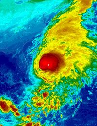
An infrared satellite image of Hurricane Noel, taken Nov. 1, 2007.
Courtesy NOAA

­On Halloween Day 2007, a tropical storm named Noel by the National Oceanic and Atmospheric Administration (NOAA) escalated. The storm was seated over Haiti, the Dominican Republic, and Cuba, before picking up enough strength from the warm Caribbean air to develop into a Category 1 hurricane as it approached the northwestern Bahamas on Nov. 1, 2007. Hurricane Noel's winds reached 80 mph in t­he Caribbean before it moved up the Atlantic coast of the United States and finally disintegrated in Nova Scotia.

In its wake, Noel left at least 160 people dead in the Caribbean islands [source: NOAA]. It didn't turn out to be the strongest storm of the 2007 Atlantic hurricane season, but Noel was the deadliest. And the impression it left on meteorologists was enough for the World Meteorological Organization to retire Noel from the list of storm names [source: NOAA].

Advertisement

But in addition to leaving destruction and death in its wake, Hurricane Noel also left behind a breakthrough in scientific research. It was the first hurricane to host the remote controlled airplane called the Aerosonde. This unmanned aerial system (UAS) was developed by NASA and NOAA and launched from Wallops Flight Center in Delaware as the storm approached on Nov. 2. Aerosonde made history as the first unmanned vehicle to fly into the eye of a hurricane [source: WFC]. Eighty miles off the coast of the United States, Aerosonde explored the hurricane wall at altitudes as low as 300 feet (91 meters), sending real-time information about temperature, wind speed and atmospheric pressure back to hurricane researchers.

Like tornadoes, much of how hurricanes work remains a mystery to meteorologists. The information provided by Aerosonde will help researchers better predict what tropical depressions and storms will develop into full-blown hurricanes. Aerosonde represents a huge leap forward in hurricane research. It also signals the beginning of the end of another type of research: Aerosonde and other UASs will eventually replace the people who risk life and limb by flying airplanes into hurricanes.

On the next page, read a brief history of the seemingly insane pursuit of manned flight into hurricanes.

Advertisement
Flying into the Storm

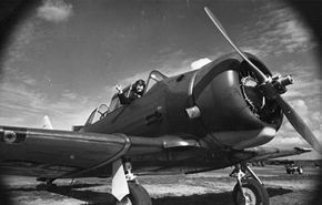
A 1945 photo of an AT-6 two-passenger fighter plane, the first to be flown into a hurricane. See more flight pictures.
Hulton Archive/Getty Images

OK, so people today fly airplanes into hurricanes to gather data. That much is understandable. But why would anyone fly into a hurricane before the Weather Bureau or the National Oceanic and Atmospheric Association (NOAA) ever existed to accept weather data?

"Just for fun," was the answer given by Col. Joe Duckworth [source: Coleman and McCloud]. He and Lt. Ralph O'Hair, both flyboys for the Army Air Corps were among the first people to fly an airplane into a hurricane. In July 1943, Duckworth and O'Hair flew a small AT-6 prop plane into the eye of a hurricane with 132 mph winds off the coast of Galveston, Texas [source: Old Farmer's Almanac]. While the pilot and navigator won highballs at the officer's club after safely returning that day, the prize for science was much more pronounced: The thermometers aboard the plane recorded a 25-degree Fahrenheit (14 degrees Celsius) difference in temperature between the eye of the hurricane and the air circling it.

Advertisement

­Flight Image Gallery

Duckworth and O'Hair's flight into the Texas hurricane proved two things: It's possible to fly into hurricanes and survive, and such flights could provide valuable scientific information. Following that excursion, manned flights into some of nature's most severe storms became more frequent.

The next year, Navy and Army flights successfully tracked an Atlantic hurricane along the United States' Eastern seaboard. The coordinated flights reported on the hurricane's path and were credited with saving lives; a surprise storm had killed 600 people in New England six years before, while the 1944 storm (about which residents were forewarned) took only 50 lives [source: USA Today].

The advent of satellites in the 1960s made it virtually impossible for a hurricane to surprise anyone. Land-based researchers use satellite imaging to track the development and movement of every storm as it forms at sea. While these images provide information about the size and direction of a hurricane, there's still plenty of data associated with these meteorological phenomena that can't be culled from photos. Images provide overviews of a storm; to get the details, one must go inside.

Today, most manned flights into hurricanes are undertaken by the Air Force's 53rd Weather Reconnaissance Squadron (popularly called the Hurricane Hunters) and the NOAA. NOAA mans 8-hour flights into storms, going from one side into the eye, back into the storm and out the other side several times per flight [source: National Science Foundation]. NOAA drops a Dropwindsonde device into the storm to gather real-time data about the characteristics of a storm from top to bottom. The 53rd Weather Reconnaissance Squadron flies out of Keesler Air Force Base, Miss., and keeps track of Atlantic hurricanes with a flight crew operation of 20 people [source: 403rd].

Together, NOAA and the Air Force (and occasionally NASA) provide in situ (on location) data about hurricanes as they unfold. But the airplanes used by both groups have drawbacks. These are large, lumbering transport planes, like the C-130, and they don't fly quite as fast as necessary to provide the data needed to truly map the minute-to-minute changes in a hurricane [source: Henning]. The need for this kind of information still exists; until we fully understand all of the processes that create and direct a hurricane, we'll never be able to confidently model and predict future storms. With the advent of unmanned vehicles that can fly into hurricanes, it looks like this data will be provided without maverick humans flying into the storms.

For more information on hurricanes and other related topics, visit the next page.

Advertisement

Lots More Information

­Related HowStuffWorks Articles
More Great Links

Sources

  • Cascella, Guy. "Identifying the inner-core characteristics of Hurricane Noel (2­007) via the unmanned aerial vehicle, the Aerosonde." University of Miami. March 5, 2008. http://www.rsmas.miami.edu/divs/mpo/About_MPO/Seminars/2008/Cascella-Abstract.pdf
  • Coleman, Sandra and McCloud, Sam, Ph.D. "A brief history of storm chasing." National Association of Storm Chasers and Spotters. http://www.chasingstorms.com/history.html
  • Henning, Richard G. "Gathering in-situ data using aircraft reconnaissance to investigate incipient tropical cyclogenesis." 53rd Weather Reconnaissance Squadron. May 3, 2004. http://ams.confex.com/ams/26HURR/techprogram/paper_75644.htm
  • Williams, Jack. "Why and how people fly into hurricanes." USA Today. July 16, 2003. http://www.usatoday.com/weather/hurricane/2003-07-16-flying-hurricanes_x.htm
  • "Dean, Felix and Noel retired from list of storm names." National Oceanic and Atmospheric Administration. May 13, 2008. http://www.noaanews.noaa.gov/stories2008/20080513_stormnames.html
  • "Flying into a hurricane: a firsthand account." National Science Foundation. March 27, 2008.­ http://www.nsf.gov/discoveries/disc_summ.jsp?cntn_id=111167
  • "Hurricane reconnaissance." Washington Post. http://www.washingtonpost.com/wp-srv/weather/hurricane/info/recon.htm
  • "NASA and NOAA fly unmanned aircraft into Hurricane Noel." Wallops Flight Facility. November 8, 2007. http://www.nasa.gov/centers/wallops/news/story105.html
  • ­"Predicting hurricanes­: The eyes have it." The Old Farmer's Almanac. http://www.almanac.com/weathercenter/predicthurricanes.php

Advertisement

Loading...