Types of Satellites
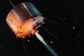
Down on the ground, satellites can look very similar -- shiny boxes or cylinders adorned with solar-panel wings. But out in space, these gawky machines behave quite differently depending on their flight path, altitude and orientation. As a result, classifying satellites can be tricky business. One approach is to think about how a device orbits its target planet (usually Earth). Recall that there are two basic shapes of an orbit: circular and elliptical. Some satellites start out elliptical and then, with corrective nudges from small onboard rockets, acquire circular paths. Others move permanently in elliptical paths known as Molniya orbits. These objects generally circle from north to south, over Earth's poles, and take about 12 hours to make one complete trip.
Polar-orbiting satellites also pass over the planet's poles on each revolution, although their orbits are far less elliptical. The polar orbit remains fixed in space as Earth rotates inside the orbit. As a result, much of Earth passes under a satellite in a polar orbit. Because polar orbits achieve excellent coverage of the planet, they are often used for satellites that do mapping and photography. And weather forecasters rely on a worldwide network of polar satellites, which covers the entire globe every 12 hours.
Advertisement
You can also classify satellites based on their height above Earth's surface. Using this scheme, there are three categories [source: Riebeek]:
- Low-Earth orbits (LEO) — LEO satellites occupy a region of space from about 111 miles (180 kilometers) to 1,243 miles (2,000 kilometers) above Earth. Satellites moving close to the Earth's surface are ideal for making observations, for military purposes and for collecting weather data.
- Geosynchronous orbits (GEO) – GEO satellites orbit Earth at an altitude greater than 22,223 miles (36,000 kilometers) and their orbital period is the same as Earth’s rotational period: 24 hours. Included in this category are geostationary (GSO) satellites, which remain in orbit above a fixed spot on Earth. Not all geosynchronous satellites are geostationary. Some have elliptical orbits, which means they drift east and west over a fixed point on the surface during the course of a full orbit. Some have orbits that are not aligned with Earth’s equator. These orbital paths are said to have degrees of inclination. It also means the satellite’s path will take it north and south of Earth’s equator during one full orbit. Geostationary satellites have to fly above Earth’s equator to remain in a fixed spot above Earth. Several hundred television, communications and weather satellites all use geostationary orbits. It can get pretty crowded.
- Medium-Earth orbits (MEO) — These satellites park in between the low and high flyers, so from about 1,243 miles (2,000 kilometers) to 22,223 miles (36,000 kilometers). Navigation satellites, like the kind used by your car's GPS, work well at this altitude. Sample specs for such a satellite might be an altitude of miles (20,200 kilometers) and an orbital speed of 8,637 mph (13,900 kph).
Finally, it's possible to think about satellites in terms of where they're "looking." Most of the objects sent into space over the last few decades look down at Earth. These satellites have cameras and equipment capable of seeing our world through various wavelengths of light, making it possible to enjoy spectacular visible, ultraviolet and infrared views of our changing planet. A smaller number of satellites turn their "eyes" toward space, where they capture magnificent vistas of stars, planets and galaxies and scan for objects, such as asteroids or comets, that could be heading for a collision course with Earth.
