How Earthquakes Work

Japanese military search a collapsed building for bodies in March 2011, two weeks after the 9-magnitude earthquake.
Paula Bronstein/Getty Images

Have you ever assured someone that your friend is reliable by saying that he or she "has both feet on the ground"? The fact that such a phrase exists shows how much comfort we take in the idea that the ground beneath our feet is unmoving, unchanging and dependable. Indeed, much of our civilization, from our houses and buildings to our energy, food and water sources, depends on unmoving earth.

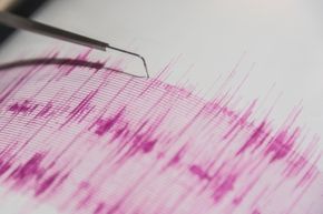
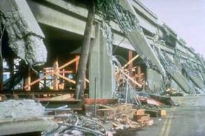
In truth, however, our planet's seemingly stable surface is made up of enormous pieces of rock that are slowly but constantly moving. Those pieces continually collide with and rub against one another, and sometimes their edges abruptly crack or slip and suddenly release huge amounts of pent-up energy. These unsettling events are called earthquakes, and small ones happen across the planet every day, without people even noticing. But every so often, a big earthquake occurs, and when that happens, the pulses of energy it releases, called seismic waves, can wreak almost unfathomable destruction and kill and injure many thousands of people [source: Bolt].

Advertisement

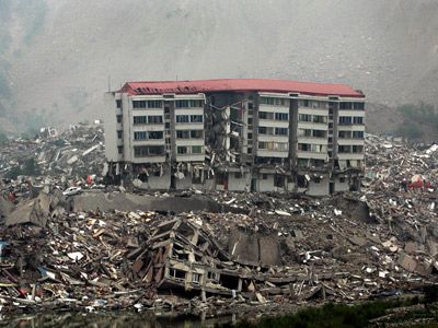
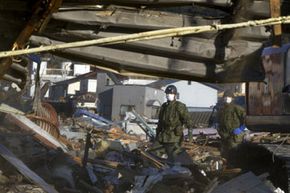
That sort of cataclysm occurred on March 11, 2011, in Japan, when a massive quake, later estimated by Japanese Meteorological Agency to be 9.0 in magnitude, struck 81 miles (130 kilometers) east of the city of Sendai on the nation's northeastern coast. The forces of the quake, the fifth most powerful in the past century, set off a giant wave, called a tsunami, that engulfed villages, destroyed buildings and drowned and crushed people who lived there [source: Green]. The earthquake and tsunami also badly damaged a six-reactor nuclear power plant in Fukushima, 150 miles (241 kilometers) north of Tokyo, destroying the backup generators that powered its cooling systems and causing a dangerous release of radiation that forced people in the region to flee. In all, the quake claimed the lives of 20,896 people, according to the U.S. Geological Survey.

Though earthquakes have terrorized people since ancient times, it's only been in the past 100 years that scientists have come to understand what causes them, and to develop technology to detect their origin and measure their magnitude. In addition, engineers and architects have worked to make buildings more resistant to earthquake shocks. Someday, researchers hope to find a way to predict earthquakes in advance, and perhaps even control them.

In this article, we'll give you the latest scientific knowledge about earthquakes, and discuss how humans can cope with them. But first, here are some basic earthquake facts.

Earthquake Facts

Technically, an earthquake is a vibration that travels through the Earth's crust. Quakes can be caused by a variety of things, including meteor impacts and volcanic eruptions, and even sometimes man-made events like mine collapses and underground nuclear tests [source: Hamilton]. But most naturally occurring earthquakes are caused by movement of pieces of the Earth's surface, which are called tectonic plates. (We'll learn more about those plates on the next page.)

The U.S. Geological Survey estimates that, each year, there are as many as 1.3 million quakes with a magnitude greater than 2.0, the threshold at which humans can feel the vibrations [source: USGS]. The vast majority of them are very small, and many occur in remote areas far from people, so we don't usually even notice them. The earthquakes that capture our attention are the rare big ones that strike near heavily populated areas. Such earthquakes have caused a great deal of property damage over the years, and they've claimed many lives. Over the last decade alone, earthquakes and the tsunamis, avalanches and landslides caused by them -- have killed 688,000 people around the world [source: Stoddard].

Advertisement

Perhaps the most lethal quake in history had a magnitude of 8.0 and struck China's Shanxi Province in 1556. According to historical accounts, city walls, temples, government buildings and houses all crumbled, and more than 830,000 people were killed. A scholar named Qin Keda, who survived the quake, later provided what may have been the first earthquake preparedness advice in history: "At the very beginning of the earthquake, people indoors should not go out immediately," he recommended. "Just crouch down and wait for chances. Even if the nest is collapsed, some eggs in it may still be kept intact" [source: Science Museums of China].

On the next page, we'll examine the powerful forces that cause this intense trembling and we'll discuss why earthquakes occur much more often in certain regions.

Plate Tectonics

Railroad tracks shifted by the 1976 Guatemala earthquake
Photo courtesy USGS

The earliest documented earthquake occurred in China in 1177 B.C. But for most of history, people didn't really have any idea what caused them -- though they had some wild theories, such as the belief earthquakes were caused by air rushing out of caverns deep in the Earth's interior. It wasn't until the mid-1800s that scientists began to study and measure earthquake activity in earnest, using a device developed in Italy called the seismograph [source: USGS, Shearer]. Finally, in the mid-1960s, researchers in the United States and Great Britain came up with a theory that explained why the Earth shook [source: Silverstein].

The theory, called plate tectonics, is that the Earth's crust, or lithosphere, comprises many plates that slide over a lubricating asthenosphere layer. At the boundaries between these huge plates of rock and soil, the plates sometimes move apart, and magma, or molten rock, comes to the surface, where it's called lava. It cools and forms new parts of the crust. The line where this happens is called a divergent plate boundary.

Advertisement

The plates also can push against each other. Sometimes, one of the plates will sink underneath the other into the hot layer of magma beneath it and partially melt. Other times, the edges of the two plates will push against each other and rise upward, forming mountains. This area is called a convergent plate boundary [source: Silverstein].

But in other instances, plates will slide by and brush against each other -- a little like drivers on the highway sideswiping each other, but very, very slowly. At the region between the two plates, called a transform boundary, pent-up energy builds in the rock. A fault line, a break in the Earth's crust where blocks of crust are moving in different directions, will form. Most, though not all, earthquakes happen along transform boundary fault lines.

We'll delve into the different types of faults on the next page.

Faults

There are four types of earthquake faults, which are differentiated by the relative position of the fault plane -- that is, the flat surface along which there's a slip during an earthquake.

In a normal fault (see animation below), the fault plane is nearly vertical. The hanging wall, the block of rock positioned above the plane, pushes down across the footwall, which is the block of rock below the plane. The footwall, in turn, pushes up against the hanging wall. These faults occur where the crust is being pulled apart, at a divergent plate boundary.

Advertisement

The fault plane in a reverse fault is also nearly vertical, but the hanging wall pushes up, and the footwall pushes down. This sort of fault forms where a plate is being compressed. A thrust fault moves the same way as a reverse fault, but at an angle of 45 degrees or less [source: USGS]. In these faults, which are also caused by compression, the rock of the hanging wall is actually pushed up on top of the footwall at a convergent plate boundary.

In a strike-slip fault, the blocks of rock move in opposite horizontal directions. These faults form when crust pieces slide along each other at a transform plate boundary. The San Andreas Fault in California is one example of a transform plate boundary.

With all these faults, rocks push together tightly, creating friction. If there's enough friction, they become locked, so that they won't slide anymore. Meanwhile, the Earth's forces continue to push against them, increasing the pressure and pent-up energy. If the pressure builds up enough, it will overcome the friction, the lock will give way suddenly, and the rocks will snap forward. To put it another way, as the tectonic forces push on the "locked" blocks, potential energy builds. When the plates are finally moved, this built-up energy becomes kinetic.

The sudden, intense shifts along already formed faults are the main sources of earthquakes. Most earthquakes occur around plate boundaries because this is where strain from plate movements is felt most intensely, creating fault zones, groups of interconnected faults. In a fault zone, the release of kinetic energy at one fault may increase the stress -- the potential energy -- in a nearby fault, leading to other earthquakes. That's one reason why several earthquakes may occur in an area in a short period of time.

These additional quakes are called foreshocks and aftershocks. The quake with the largest magnitude is called the mainshock; any quakes that occur before the mainshock are called foreshocks, and any quakes that occur after the mainshock are called aftershocks. Most of the time, the worst aftershocks occur within the first 24 hours after the mainshock hits. Bigger earthquakes trigger more aftershocks with larger magnitudes.

In the next section, we'll talk about the waves of energy that earthquakes generate, and the effects that they cause.

Seismic Waves

When you toss a pebble into a pond, it creates radiating waves in the water. An earthquake does the same thing with energy. When the plates fracture or slip, energy is released as seismic waves [source: USGS].

There are several types of seismic waves. Body waves move through the inside of the Earth. There are two types of body waves:

Advertisement

Primary waves (or P waves) are the fastest moving waves, traveling at 1 to 5 miles per second (1.6 to 8 kilometers per second). They can pass through solids, liquids and gases easily. As they travel through rock, the waves move tiny rock particles back and forth -- pushing them apart and then back together -- in line with the direction the wave is traveling. These waves typically arrive at the surface as an abrupt thud.

Secondary waves (also called shear waves, or S waves) are another type of body wave. They move a little more slowly than P waves, and can only pass through solids. As S waves move, they displace rock particles outward, pushing them perpendicular to the path of the waves. This results in the first period of rolling associated with earthquakes. Unlike P waves, S waves don't move straight through the Earth. They only travel through solid material, and so are stopped at the liquid layer in the Earth's core.

Unlike body waves, surface waves (also known as long waves, or simply L waves) move along the surface of the Earth. Surface waves are to blame for most of an earthquake's carnage. They move up and down the surface of the Earth, rocking the foundations of man-made structures. Surface waves are the slowest moving of all waves, which means they arrive the last. So the most intense shaking usually comes at the end of an earthquake.

How do scientists calculate the origin of an earthquake by detecting these different waves?

Seismology

A seismometer is hard at work detecting what's shaking with the ground.
Gary S Chapman/Getty Images

On the last page, you learned that there are three different types of seismic waves, and that these waves travel at different speeds. While the exact speed of primary waves (P waves) and secondary waves (S waves) varies depending on the composition of the material they're traveling through, the ratio between the speeds of the two waves will remain relatively constant in any earthquake. P waves generally travel 1.7 times faster than S waves [source: Stein].

Using this ratio, scientists can calculate the distance between any point on the Earth's surface and the earthquake's focus, the breaking point where the vibrations originated. They do this with a seismograph, a machine that registers the different waves. To find the distance between the seismograph and the focus, scientists also need to know the time the vibrations arrived. With this information, they simply note how much time passed between the arrival of both waves and then check a special chart that tells them the distance the waves must have traveled based on that delay.

Advertisement

If you gather this information from three or more points, you can determine the location of the focus through a process called trilateration. Basically, you draw an imaginary sphere around each seismograph location, with the point of measurement as the center and the measured distance (let's call it X) from that point to the focus as the radius. The surface of the circle describes all the points that are X miles away from the seismograph. The focus, then, must be somewhere along this sphere.

If you come up with two spheres, based on evidence from two different seismographs, you'll get a two-dimensional circle where they meet. Since the focus must be along the surface of both spheres, all of the possible focus points are located on the circle formed by the intersection of these two spheres. A third sphere will intersect only twice with this circle, giving you two possible focus points. And because the center of each sphere is on the Earth's surface, one of these possible points will be in the air, leaving only one logical focus location.

Besides determining the origin of the earthquake, scientists also want to measure its strength. Find out more about the Richter scale on the next page.

Richter Scale

Whenever a major earthquake is in the news, you'll probably hear about its Richter scale rating. You might also hear about its Mercalli Scale rating, though this isn't discussed as often. These two ratings describe the power of the earthquake from two different perspectives.

The most common standard of measurement for an earthquake is the Richter scale, developed in 1935 by Charles F. Richter of the California Institute of Technology. The Richter scale is used to rate the magnitude of an earthquake -- the amount of energy it released. This is calculated using information gathered by a seismograph.

Advertisement

The Richter scale is logarithmic, meaning that whole-number jumps indicate a tenfold increase. In this case, the increase is in wave amplitude. That is, the wave amplitude in a level 6 earthquake is 10 times greater than in a level 5 earthquake, and the amplitude increases 100 times between a level 7 earthquake and a level 9 earthquake. The amount of energy released increases 31.7 times between whole number values.

As we previously noted, most earthquakes are extremely small. A majority of quakes register less than 3 on the Richter scale; these tremors, called microquakes, aren't even felt by humans. Only a tiny portion -- 15 or so of the 1.4 million quakes that register above 2.0 -- register at 7 or above, which the threshold for a quake being considered major [source: USGS]. The biggest quake in recorded history was the 9.5 quake that struck Chile in 1960. It killed nearly 1,900 people and caused about $4 billion in damage in 2010 dollars [source: USGS]. Generally, you won't see much damage from earthquakes that register below 4 on the Richter scale.

Richter ratings only give you a rough idea of the actual impact of an earthquake, though. As we've seen, an earthquake's destructive power varies depending on the composition of the ground in an area and the design and placement of man-made structures. The extent of damage is rated on the Mercalli scale. Mercalli ratings, which are given as Roman numerals, are based on largely subjective interpretations. A low intensity earthquake, one in which only some people feel the vibration and there is no significant property damage, is rated as a II. The highest rating, a XII, is applied to earthquakes in which structures are destroyed, the ground is cracked and other natural disasters, such as landslides or tsunamis, are initiated.

Richter scale ratings are determined soon after an earthquake, once scientists can compare the data from different seismograph stations. Mercalli ratings, on the other hand, can't be determined until investigators have had time to talk to many eyewitnesses to find out what occurred during the earthquake. Once they have a good idea of the range of damage, they use the Mercalli criteria to decide on an appropriate rating.

Predicting Earthquakes

Today's scientists understand earthquakes a lot better than we did even 50 years ago, but they still can't match the quake-predicting prowess of the common toad (Bufo bufo), which can detect seismic activity days in advance of a quake. A 2010 study published in Journal of Zoology found that 96 percent of male toads in a population abandoned their breeding site five days before the earthquake that struck L'Aquila, Italy, in 2009, about 46 miles (74 kilometers) away. Researchers aren't quite sure how the toads do this, but it's believed that they can detect subtle signs, such as the release of gases and charged particles, that may occur before a quake [source: Science Daily].

Scientists can predict where major earthquakes are likely to occur, however, based on the movement of the plates in the Earth and the location of fault zones. They also can make general guesses about when earthquakes might occur in a certain area, by looking at the history of earthquakes in the region and detecting where pressure is building along fault lines. For example, if a region has experienced four magnitude 7 or larger quakes during the past 200 years, scientists would calculate the probability of another magnitude 7 quake occurring in the next 50 years at 50 percent. But these predictions may not turn out to be reliable because, when strain is released along one part of a fault system, it may actually increase strain on another part [source: USGS].

Advertisement

As a result, most earthquake predictions are vague at best. Scientists have had more success predicting aftershocks, additional quakes following an initial earthquake. These predictions are based on extensive research of aftershock patterns. Seismologists can make a good guess of how an earthquake originating along one fault will cause additional earthquakes in connected faults.

Another area of study is the relationship between magnetic and electrical charges in rock material and earthquakes. Some scientists have hypothesized that these electromagnetic fields change in a certain way just before an earthquake. Seismologists are also studying gas seepage and the tilting of the ground as warning signs of earthquakes. In 2009, for example, a technician at Italy's National Institute for Nuclear Physics claimed that he was able to predict the L'Aquila earthquake by measuring the radon gas seeping from the Earth's crust. His findings remain controversial [source: Joyce].

So, if we can't predict earthquakes, what can we do to prepare for them?

Earthquake Preparedness

Bridge columns cracked by the Loma Prieta, Calif. earthquake of 1989
Photo courtesy USGS

Over the past 50 years, major advances have been made in earthquake preparedness -- particularly in the field of construction engineering. In 1973, the Uniform Building Code, an international set of standards for building construction, added specifications to fortify buildings against the force of seismic waves. This includes strengthening support material as well as designing buildings so they're flexible enough to absorb vibrations without falling or deteriorating. It's very important to design structures that can take this sort of punch, particularly in earthquake-prone areas.

But architects and engineers also are trying to develop innovations that would provide even greater protection against quakes. Greg Deierlein of Stanford University and Jerome Hajjar of Northeastern University, for example, have designed a structure equipped with structural "fuses" that, instead of toppling, deliberately collapse upon themselves and then reform after the quake subsides [source: Ward].

Advertisement

Additionally, scientists are developing "smart" building materials that are capable of coping with the tremendous forces generated by a quake. One idea is to include fiber-optic sensors that can sense when a structure is about to fail; the sensors would then send signals to tiny ceramic strips built into the walls and frame, which would change shape to absorb the energy [source: Stark]. (See How Smart Structures Will Work for more on how scientists are creating new ways to protect buildings from seismic activity.)

Another component of preparedness is educating the public. The United States Geological Survey (USGS) and other government agencies have produced several brochures explaining the processes involved in an earthquake and giving instructions on how to prepare your house for a possible earthquake, as well as what to do when a quake hits.

In the future, improvements in prediction and preparedness should further minimize the loss of life and property associated with earthquakes. But it will be a long time, if ever, before we'll be ready for every substantial earthquake that might occur. Just like severe weather and disease, earthquakes are an unavoidable force generated by the powerful natural processes that shape our planet. All we can do is increase our understanding of the phenomenon and develop better ways to deal with it. 

Lots More Information

Related Articles

More Great Links

  • Bolt, Bruce. "Earthquake." Brittanica.com. April 6, 2011. (April 6, 2011) http://www.britannica.com/EBchecked/topic/176199/earthquake
  • "Death toll reaches 12,468 from great quake-tsunami in Japan." English.news.cn. April 6, 2011. (April 6, 2011) http://news.xinhuanet.com/english2010/world/2011-04/06/c_13815236.htm
  • Hamilton, R.M.; Smith, B.E.; Fischer, F.G.; and Papanek, P.J. "Earthquakes caused by underground nuclear explosions on Pahute Mesa, Nevada Test Site." Bulletin of the Seismological Society of America. October 1972. (April 6, 2011) http://bssa.geoscienceworld.org/cgi/content/abstract/62/5/1319
  • "Japan upgrades killer quake's magnitude." CBSnews.com. March 13, 2011. (April 6, 2011) http://www.cbsnews.com/8301-503543_162-20042549-503543.html
  • Joyce, Christopher. "Can Scientists Predict When Quakes Will Strike?" NPR. April 7, 2009. (April 6, 2011)http://www.npr.org/templates/story/story.php?storyId=102964813
  • Shearer, Peter. "A Brief History of Seismology." U.S. Geological Survey. (April 6, 2011) http://earthquake.usgs.gov/hazards/about/workshops/thailand/downloads/CSMpp1_History.pdf
  • Silverstein, Alvin et.al. "Plate Tectonics." Twenty-First Century Books. 2009. (April 6, 2011) http://books.google.com/books?id=th5iDsd0cvEC&printsec=frontcover&dq=plate+tectonics&hl=en&ei=hM2cTYbZCNGdgQfB_KSbBw&sa=X&oi=book_result&ct=result&resnum=2&ved=0CDoQ6AEwAQ#v=onepage&q&f=false
  • Stoddard, Kate. "All the deadliest and strongest earthquakes since 1900, including coordinates." Guardian.co.uk. Feb. 28, 2010. (April 6, 2011) http://www.guardian.co.uk/news/datablog/2010/feb/28/deadliest-earthquakes-strongest-data
  • "Toads' Earthquake Exodus." Science Daily. April 1, 2010. (April 6, 2011) http://www.sciencedaily.com/releases/2010/03/100330210949.htm
  • University of Washington, physics department."How do earthquakes generate tsunamis?" (April 6, 2011) http://www.ess.washington.edu/tsunami/general/physics/earthquake.html
  • U.S. Geological Survey (USGS). "Earthquake Glossary." Earthquake Hazards Program. (April 6, 2011) http://earthquake.usgs.gov/learn/glossary/?alpha=ALL
  • U.S. Geological Survey (USGS). "Earthquakes in History." (April 6,2011) http://pubs.usgs.gov/gip/earthq1/history.html
  • U.S. Geological Survey (USGS). "Historic Earthquakes: Chile." Earthquake Hazards Program. (April 6, 2011) http://earthquake.usgs.gov/earthquakes/world/events/1960_05_22.php
  • U.S. Geological Survey (USGS). "Largest and Deadliest Earthquakes by Year." Earthquake Hazards Program. April 13, 2011. (Aug. 15, 2012) http://earthquake.usgs.gov/earthquakes/eqarchives/year/byyear.php
  • U.S. Geological Survey (USGS). "Predicting Earthquakes." 1997. (April 6, 2011) http://pubs.usgs.gov/gip/earthq1/predict.html
  • U.S. Geological Survey (USGS). "The Science of Earthquakes." Earthquake Hazards Program. (April 6, 2011) http://earthquake.usgs.gov/learn/kids/eqscience.php