How Hurricanes Work

By: Marshall Brain, Craig Freudenrich, Ph.D. & Robert Lamb  | 
Hurricane Iota
Drone picture of a damaged road left by Hurricane Iota in San Andres, Colombia, Nov. 17, 2020. MICHAEL AREVALO/AFP via Getty Images

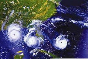
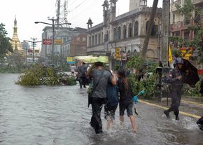
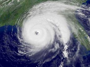
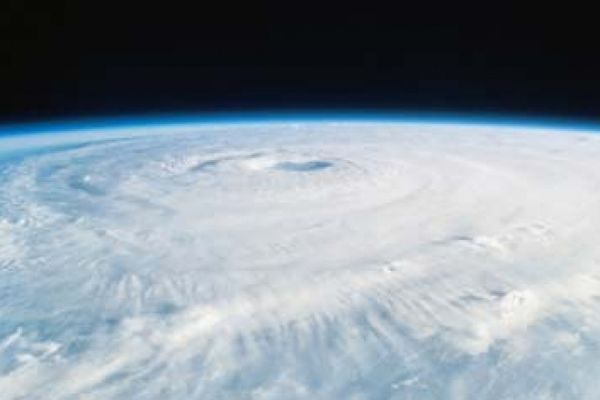
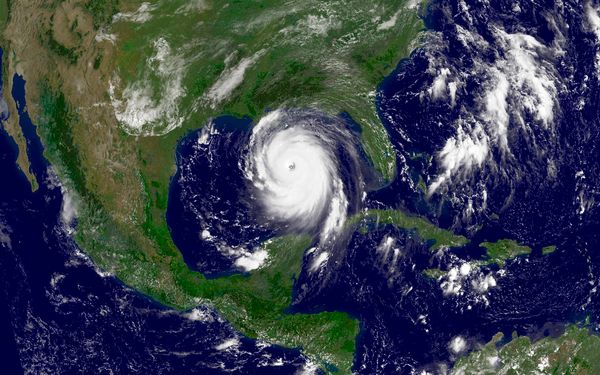
Hurricanes are powerful storms, and captivate human imagination. Hurricane Harvey hit Texas in August 2017, flooding one of the largest metro areas in the United States. Less than two weeks later, thoughts turned to hurricane Irma, among the strongest Atlantic hurricanes ever measured. And as hurricane Sandy made its way to the Eastern coast of the United States in October 2012, meteorologists called the storm unprecedented in terms of its potential for damage and fatalities, due to its path along the densely populate urban coast. Few events on Earth rival the sheer power of a hurricane. Also known as tropical cyclone and typhoons, these fierce storms can churn the seas into a violent topography of 50-foot (15-meter) peaks and valleys, redefine coastlines and reduce whole cities to watery ruin. Some researchers even theorize that the dinosaurs were wiped out by prehistoric hypercanes, a kind of super-hurricane stirred to life by the heat of an asteroid strike.

Every year, the world experiences hurricane season. During this period, hundreds of storm systems spiral out from the tropical regions surrounding the equa­tor, and between 40 and 50 of these storms intensify to hurricane levels. In the Northern Hemisphere, the season runs from June 1 to Nov. 30, while the Southern Hemisphere generally experiences hurricane activity from January to March. So 75 percent of the year, it's safe to say that someone somewhere is probably worrying about an impending hurricane.

Advertisement

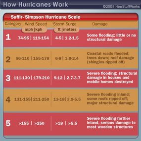
A hurricane builds energy as it moves across the ocean, sucking up warm, moist tro­pical air from the surface and dispensing cooler air aloft. Think of this as the storm breathing in and out. The hurricane escalates until this "breathing" is disrupted, like when the storm makes landfall. At this point, the storm quickly loses its momentum and power, but not without unleashing wind speeds as high as 185 mph (300 kph) on coastal areas.

­In this article, we'll explore the lifecycle and anatomy of a hurricane, as well as the methods we use to classify and track these ultimate storm systems as they hurtle across the globe.

Advertisement

Defining a Hurricane

Barometers are one way to measure atmospheric pressure.
Peter Dazeley/Getty Images

To understand how a hurricane works, you have to understand the basic principles of atmospheric pressure. The gases that make up Earth's atmosphere are subject to the planet's gravity. In fact, the atmosphere weighs in at a combined 5.5 quadrillion tons (4.99 quadrillion metric tons). The gas molecules at the bottom, or those closest to the Earth's surface where we all live, are compressed by the weight of the air above them.

The air closest to us is also the warmest, as the atmosphere is mostly heated by the land and the sea, not by the sun. To understand this principle, think of a person frying an egg on the sidewalk on a hot, sunny day. The heat absorbed by the pavement actually fries the egg, not the heat coming down from the sun. When air heats up, its molecules move farther apart, making it less dense. This air then rises to higher altitudes where air molecules are less compressed by gravity. When warm, low-pressure air rises, cool, high-pressure air seizes the opportunity to move in underneath it. This movement is called a pressure gradient force.

Advertisement

These are some of the basic forces at work when a low-pressure center forms in the atmosphere -- a center that may turn into what people in the North Atlantic, North Pacific and Caribbean regions call a hurricane. What else is happening? Well, as we know, warm, moist air from the ocean's surface begins to rise rapidly. As it rises, its ­water vap­or condenses to form storm clouds and droplets of rain. The condensation releases heat called latent heat of condensation. This latent heat warms the cool air, causing it to rise. This rising air is replaced by more warm, humid air from the ocean below. And the cycle continues, drawing more warm, moist air into the developing storm and moving heat from the surface to the atmosphere. This exchange of heat creates a pattern of win­d that circulates around a center, like water going down a drain.

But what about those signature ferocious winds? Converging winds at the surface are colliding and pushing warm, moist air upward. This rising air reinforces the air that's already ascending from the surface, so the circulation and wind speeds of the storm increase. In the meantime, strong winds blowing the same speed at higher altitudes (up to 30,000 feet or 9,000 meters) help to remove the rising hot air from the storm's center, maintaining a continual movement of warm air from the surface and keeping the storm organized. If the high-altitude winds don't blow at the same speed at all levels -- if wind shears are present -- the storm becomes disorganized and weakens.

­Even higher in the atmosphere (above 30,000 feet or 9,000 meters) high-pressure air over the storm's center also removes heat from the rising air, further driving the air cycle and the hurricane's growth. As high-pressure air is sucked into the low-pressure center of the storm, wind speeds increase. Then you have a hurricane to contend with.

Advertisement

How a Hurricane Forms

You never hear about hurricanes hitting Alaska. That's because hurricanes develop in warm, tropical regions where the water is at least 80 degrees Fahrenheit (27 degrees Celsius). The storms also require moist air and converging equatorial winds. Most Atlantic hurricanes begin off the west coast of Africa, starting as thunderstorms that move out over the warm, tropical ocean waters.­

A hurricane's low-pressure center of relative calm is called the eye. The area surrounding the eye is called the eye wall, where the storm's most violent winds occur. The bands of thunderstorms that circulate outward from the eye are called rain bands. These storms play a key role in the evaporation/condensation cycle that feeds the hurricane.

Advertisement

The rotation of a hurricane is a product of the Coriolis force, a natural phenomenon that causes fluids and free-moving objects to veer to the right of their destination in the Northern Hemisphere and to the left in the Southern Hemisphere. Imagine flying a small plane directly south. While you're moving southward, the planet is rotating. If you plotted a flight from the North Pole to the equator on a map, the path will appear to curve to the right.

So in the Northern Hemisphere, winds deflect to the right. In the Southern Hemisphere, they deflect to the left. This wind deflection gets storms spinning. As a result, hurricanes in the Northern Hemisphere rotate counterclockwise and clockwise in the Southern Hemisphere. The force also affects the actual path of the hurricane, bending them to the right (clockwise) in the Northern Hemisphere and to the left (counterclockwise) if you're south of the equator. If you can't remember, just move within five degrees of the equator; the Coriolis force is too weak there to help form hurricanes.

Hurricanes often begin their lives as clusters of clouds and thunderstorms called tropical disturbances. These low-pressure areas feature weak pressure gradients and little or no rotation. Most of these disturbances die out, but a few persevere down the path to hurricane status. In these cases, the thunderstorms in the disturbance release latent heat, which warms areas in the disturbance. This causes the air density inside the disturbance to lower, dropping the surface pressure. Wind speeds increase as cooler air rushes underneath the rising warm air. As this wind is subject to the Coriolis force, the disturbance begins to rotate. The incoming winds bring in more moisture, which condenses to form more cloud activity and releases latent heat in the process.

Advertisement

Lifecycle of a Hurricane

This photo is a composite of three days' views (Aug. 23, 24 and 25, 1992) of Hurricane Andrew as it slowly moved across south Florida from east to west.
Photo courtesy NASA

Given the destruction the storm unleashes, it's easy to think of a hurricane as a kind of monster. It may not be a living organism, but it does require sustenance in the form of warm, moist air. And if a tropical disturbance continues to find enough of this "food" and to encounter optimal wind and pressure conditions, it will just keep growing.

It can take anywhere from hours to days for a tropical disturbance to develop into a hurricane. But if the cycle of cyclonic activity continues and wind speeds increase, the tropical disturbance advances through three stages:

Advertisement

  1. Tropical depression: wind speeds of less than 38 mph
  2. Tropical storm: wind speeds of 39 to 73 mph
  3. Hurricane: wind speeds greater than 74 mph

Between 80 and 100 tropical storms develop each year around the world. Many of them die out before they can grow too strong, but around half of them eventually achieve hurricane status.

Hurricanes vary widely in physical size. Some storms are compact, with only a few bands of wind and rain trailing behind them. Other storms are looser -- the bands of wind and rain spread out over hundreds or thousands of miles. Hurricane Floyd, which hit the eastern United States in September 1999, was felt from the Caribbean islands to New England.

Once a hurricane has formed and intensified, the only remaining path for the atmospheric juggernaut is dissipation. Eventually, the storm will encounter conditions that deny it the warm, moist air it requires. When a hurricane moves onto cooler waters at a higher latitude, gradient pressure decreases, winds slow, and the entire storm is tamed, from a tropical cyclone to a weaker extratropical cyclone that peters out in days.

That important supply of warm, moist air also vanishes when the hurricane makes landfall. Condensation and the release of latent heat diminishes, and the friction of an uneven landscape decreases wind speeds. This causes winds to move more directly into the eye of the storm, eliminating the large pressure difference that fuels the storm's awesome power.

Advertisement

Hurricane Categories

Hurricanes can unleash incredible damage when they hit. With enough advance warning though, cities and coastal areas can give residents the time they need to fortify the area and even evacuate. To better classify each hurricane and prepare those affected for the intensity of the storm, meteorologists rely on rating systems.

There are five categories, according to the Saffir-Simpson scale:

Advertisement

Saffir-Simpson Hurricane Scale
A Category 5 hurricane should have running for safe ground in a hurry.
HowStuffWorks
  • Category 1 storms have sustained winds of 74 to 95 miles (119 to 153 kilometers) per hour. These could damage roofs, snap tree branches and uproot some trees. Power outages can occur.
  • Category 2 storms have sustained winds of between 96 to 110 miles (154 to 177 kilometers). There could be power loss, downed streets, and major roof and siding damage to well-constructed frame houses.
  • Category 3 storms have sustained winds of 111 to 129 miles (178 to 208 kilometers) per hour. Damage to homes can be major and electricity and water could be out even weeks after the storm passes.
  • Category 4 storms have sustained winds of 130 to 156 miles (209 to 251 kilometers) per hour. Property damage can be extensive and trees could be uprooted. Power could be out for months and the area devastated by the storm could be uninhabitable for months, too.
  • Category 5 storms have sustained winds of 157 miles (252 kilometers) per hour or higher. These hurricanes will cause total roof and building failures, collapsed walls, and other damage. These homes will be uninhabitable for months.

Australian meteorologists use a slightly different scale to classify hurricanes. While the Australian scale of cyclone intensity also ranks storms by wind speed and damage on a scale of 1 to 5, it covers both hurricanes and tropical storms. Its category 1 rate starts with peak gusts at 63-88 kilometers per hour (39-55 mph) and going all the way to up category 5 (more than 200 kph or 124 mph).

Advertisement

Hurricane Damages

People walk in a flooded street in Myanmar's largest city, Yangon, on May 3, 2008, after a hurricane (although it's called a cyclone there).
AFP/Getty Images

Over the course of millennia, hurricanes have cemented their reputation as destroyers. Many people even frame them as the embodiment of nature's power or acts of divine wrath. The word "hurricane" itself actually derives from "Hurakan," a destructive Mayan god. No matter how you choose to sum up or personify these powerful acts of nature, the damage they inflict stems from several different aspects of the storm.

Hurricanes deliver massive downpours of rain. A particularly large storm can dump dozens of inches of rain in just a day or two, much of it inland. That amount of rain can create flooding, potentially devastating large areas in the path of the hurricane's fierce center.

Advertisement

In addition, high sustained winds within the storm can cause widespread structural damage to both man-made and natural structures. These winds can roll over vehicles, collapse walls and blow over trees. The prevailing winds of a hurricane push a wall of water, called a storm surge, in front of it. If the storm surge happens to coincide with high tide, it causes beach erosion and significant inland flooding.

Tornadoes: one of the bonus effects of hurricanes.
Paul & Lindamarie Ambrose/Getty Images

The hurricane itself is often just the beginning. The storm's winds often spawn tornadoes, which are smaller, more intense cyclonic storms that cause additional damage. You can read more about them in How Tornadoes Work.

The extent of hurricane damage doesn't just depend on the strength of the storm, but also the way it makes contact with the land. In many cases, the storm merely grazes the coastline, sparing the shores its full power. Hurricane damage also greatly depends on whether the left or right side of a hurricane strikes a given area. The right side of a hurricane packs more punch because the wind speed and the hurricane's speed of motion complement one another there. On the left side, the hurricane's speed of motion subtracts from the wind speed.

­This combination of winds, rain and flooding can level a coastal town and cause significant damage to cities far from the coast. In 1996, Hurricane Fran swept 150 miles (241 km) inland to hit Raleigh, N.C. Tens of thousands of homes were damaged or destroyed, millions of trees fell, power was out for weeks in some areas and the total damage was measured in the billions of dollars.

Advertisement

Tracking a Hurricane

A WC-130J Hurricane Hunter on display at Guatemala's air force base in Guatemala City in March 2008.
AFP/Getty Images

To monitor and track the development and movement of a hurricane, meteorologists rely on remote sensing by satellites, as well as data gathered by specially equipped aircraft. On the ground, Regional Specialized Meteorological Centers, a network of global centers designated by the World Meteorological Organization, are charged with tracking and notifying the public about extreme weather.

Weather satellites use different sensors to gather different types of information about hurricanes. They track visible clouds and air circulation patterns, while radar measures rain, wind speeds and precipitation. Infrared sensors also detect vital temperature differences within the storm, as well as cloud heights.

Advertisement

The Hurricane Hunters are members of the 53rd Weather Reconnaissance Squadron/403rd Wing, based at Keesler Air Force Base in Biloxi, Miss. Since 1965, the Hurricane Hunters team has used the C-130 Hercules, a very sturdy turboprop plane to fly into tropical storms and hurricanes. The only difference between this plane and the cargo version is the specialized, highly sensitive weather equipment installed on the WC-130. The team can cover up to five storm missions per day, anywhere from the mid-Atlantic to Hawaii.

The Hurricane Hunters gather information about wind speeds, rainfall and barometric pressures within the storm. They then relay this information back to the National Hurricane Center in Miami, Fla. If you're curious about these foolhardy pilots, read Why would someone fly an airplane into a hurricane?

Meteorologists take all the storm data they receive and use it to create computer forecast models, called spaghetti models. Based on a great deal of current and past statistical data, these virtual storms allow scientists to forecast a hurricane's path and changes in intensity well in advance of landfall. With this data, governments and news agencies ideally can warn residents of coastal areas and greatly reduce the loss of life during a hurricane.

­Long-term forecasting now allows meteorologists to predict how many hurricanes will take place in an upcoming season and to study trends and patterns in global climate.

Advertisement

Hurricane Names

Naming a hurricane isn't all that difficult, but naming the dead in the aftermath of a hurricane obviously is. Pictured is one of 1,464 white flags bearing the names of people who died in Louisiana as a result of Hurricane Katrina.
Getty Images

While personifying a massive, destructive force certainly makes for a jazzier headline, the practice of naming hurricanes originated with meteorologists, not media outlets. Often more than one tropical storm is active at the same time, so what better way to tell them apart than by naming them?

For several hundred years, residents of the West Indies often named hurricanes after the Catholic saint's day on which the storm made landfall. If a storm arrived on the anniversary of a previous storm, a number was assigned. For example, Hurricane San Felipe struck Puerto Rico on Sept. 13, 1876. Another storm struck Puerto Rico on the same day in 1928, so this storm was named Hurricane San Felipe the Second.

Advertisement

During World War II, weather officials only gave hurricanes masculine names. These names closely followed radio code names for letters of the alphabet. This system, like the West Indian saints system, drew from a limited naming pool. In the early 1950s, weather services began naming storms alphabetically and with only feminine names. By the late 1970s, this practice was replaced with the equal opportunity system of alternating masculine and feminine names. The World Meteorological Organization (WMO) continues this practice to this day.

The first hurricane of the season is given a name starting with the letter A, the second with the letter B and so on. As the storms affect varying portions of the globe, the naming lists draw from different cultures and nationalities.

Hurricanes in the Pacific Ocean are assigned a different set of names than Atlantic storms. For example, the first hurricane of the 2001 hurricane season was a Pacific Ocean storm near Acapulco, Mexico, named Adolf. The first Atlantic storm of the 2001 season was named Allison. A predetermined list of names for potential future storms is available from the National Hurricane Center.

If a hurricane inflicts significant damage, a country affected by the storm can request that the name of the hurricane be "retired" by the WMO. A retired name can't be reissued to a tropical storm for at least 10 years. This helps to avoid public confusion and to simplify both historical and legal record keeping.

Advertisement

Hurricane History

Hurricanes like Ivan, pictured here in September 2004 over the Gulf Coast, were here long before we were.
Photo courtesy NOAA

Our modern understanding of hurricanes depends largely on a mere century's worth of scientific study and record keeping, but the storms have been dictating the course of human history for millennia. After all, they're a part of an atmospheric system that predates the human race by billions of years.

While scientists are largely left to speculate about the strength of Mesozoic Era storms, geologists have discovered evidence of Iron Age hurricanes in layers of ground sediment. When storm surges wash over land and into lakes, they leave fans of sand behind. Scientists can carbon date organic materials above and below the sand to determine an approximate storm date.

Advertisement

A team from Louisiana State University studied thousands of years worth of lake bed evidence and discovered that, over the past 3,400 years, a dozen Category 4 or higher hurricanes hit the area -- yet most of them occurred 1,000 years or more ago [source: Young]. Findings such as these allow scientists to better study long-term weather patterns and possibly make better sense of current climate trends.

As far as human records go, the ancient Mayans of South America made some of the earliest mentions of hurricanes in their hieroglyphics. The centuries that follow are littered with accounts of hurricanes affecting the outcomes of wars, colonization efforts and an untold number of personal lives.

Just to name a few, hurricane activity thwarted the following sea ventures through the destruction and scattering of ocean fleets:

  • The 1274 Mongol invasion of Japan
  • A 1559 attempt by the Spanish to recapture Florida
  • The French defense of a Floridian fort, subsequently lost to the Spanish in 1565
  • The Spanish Armada's attack on England in 1588
  • A 1640 Dutch attack on Cuba
  • British dominance over the French and American in the Caribbean Islands in 1780

Today, modern meteorology prevents most hurricanes from arriving unannounced, greatly decreasing the massive hurricane fatality rates of previous centuries. But even with advance warning, governments and the residents of coastal areas still have to properly prepare for the coming storms.

Meanwhile, some experts look to the future with concern. Some point to periods of intense hurricane activity in Earth's past and worry that such trends may return. Others argue that global warming brought on by the increased production of greenhouse gasses will lead to larger hurricane zones and more powerful storms. After all, hurricanes thrive on warm, moist waters, and a warmer Earth could provide more sustenance for tropical storms.

Advertisement

Lots More Information

Related Articles

  • "­Atmosphere." Britannica Student Encyclopædia. 2008. (Aug. 5, 2008)http://student.britannica.com/comptons/article-196868/atmosphere
  • Drye, Willie. "Hurricanes of History -- From Dinosaur Times to Today." National Geographic News. Jan. 28, 2005. (Aug. 19, 2008) http://news.nationalgeographic.com/news/2005/01/0128_050128_tv_hurricane.html
  • "Evolution of the atmosphere." Britannica Online Encyclopædia. 2008. (Aug. 8, 2008)http://www.britannica.com/EBchecked/topic/1424734/evolution-of-the-atmosphere
  • "The History of Hurricanes." Federal Emergency Management Agency. (Aug. 21, 2008)http://www.fema.gov/kids/hurr_hist.htm
  • "Hurricane Timeline: 1495 to 1800." South Florida Sun-Sentinel. 2008. (Aug. 21, 2008)http://www.sun-sentinel.com/news/weather/hurricane/sfl-hc-history-1495to1800,0,3354030.htmlstory
  • "Jet stream." Britannica Online Encyclopædia. 2008. (Aug. 8, 2008)http://www.britannica.com/EBchecked/topic/303269/jet-stream
  • "Lightning." Britannica Online Encyclopædia. 2008. (Aug. 8, 2008)http://www.britannica.com/EBchecked/topic/340767/lightning#default
  • Reynolds, Ross. "Cambridge Guide to Weather." Cambridge University Press. 2000.
  • Tarbuck, Edward and Frederick Lutgens. "Earth Science: Eleventh Edition." Pearson Prentice Hall. 2006.
  • Toothman, Jessika. "How Clouds Work." HowStuffWorks.com. May 5, 2008. (Aug. 8, 2008)https://science.howstuffworks.com/cloud.htm
  • "Tropical Cyclone." Britannica Online Encyclopædia. 2008. (Aug. 20, 2008)http://www.britannica.com/EBchecked/topic/606551/tropical-cyclone
  • Vogt, Gregory L. "The Atmosphere: Planetary Heat Engine." Twenty-First Century Books. 2007.
  • Wilson, Tracy V. "How the Earth Works." HowStuffWorks.com. April 21, 2006. (Aug. 8, 2008)https://science.howstuffworks.com/Earth.htm
  • Young, Emma. "Raiders of the lost storms." New Scientist. June 10, 2006. (Aug. 21, 2008)http://environment.newscientist.com/channel/earth/hurricane-season/mg19025551.300-raiders-of-the-lost-storms.html

Advertisement

Loading...